

View Information About HSR Ratings
Additional Information: As of 2022, the greatest mystery on HistoricBridges.org remains unsolved. Where exactly did this bridge come from? The Allegheny River is a large river with big bridges and it is unusual after all these years that no photographs have been found. This leads one to suspect it may have been located fairly close to the source of the river where it would have been smaller with less famous bridges. A local news article did say that R. L. Erickson of Bessemer, Michigan got the contract to install the bridge (noted as a 268 foot clear span) but does not say where the truss came from. Another article did state that "material has been shipped from Pittsburgh" but that does not mean this is where the bridge itself was originally located.

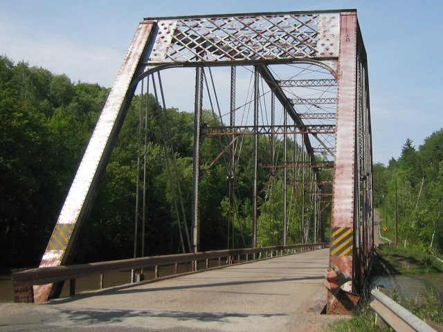
This is one of the largest, most beautiful, and most significant truss spans in Michigan. Not only does this truss bridge display the Pennsylvania truss configuration, it appears that it may have actually come from the state of Pennsylvania. In 1919, the Michigan State Highway Department purchased the bridge which originally crossed the Allegheny River. Relocating and reusing truss bridges was not unusual in this period of history. An example notice indicating bridges for sale from 1921 is shown to the right. At this time, CR-510 was a state trunk line route and purchasing and relocating this bridge would have been an inexpensive alternative to building a new bridge from scratch. It was erected on the CR-510 location in 1921. The Michigan State Highway Department's Biennial Report stated that the bridge was one of two toll bridges crossing the Allegheny River within 500 feet of each other and was being removed due to the redundancy. Unfortunately, the report did not state exactly where on the river this bridge came from. Since most of the Allegheny River is in Pennsylvania, it is assumed the bridge came from Pennsylvania, although the Allegheny River does dip into New York State for a short time. Depending on where on the Allegheny River it was originally located, it may have been part of a multi-span bridge.
Pennsylvania truss bridges are an uncommon truss type, and the nature of their design means that they are reserved for longer truss spans. However, even among pin-connected highway Pennsylvania truss spans, this bridge's span still stands out as fairly long. It is the longest pin-connected highway truss span in Michigan. The truss type is extremely rare in Michigan, and so the bridge has additional significance in the context of Michigan. The bridge also retains excellent historic integrity with minimal alterations despite its long service and being located in two different states over its service life. The bridge has decorative details on its portal bracing, another feature that is rare among Michigan truss bridges.
In 2010, this bridge was replaced by a new high level bridge on new alignment a short distance west of the historic bridge. Fortunately, Marquette County did not demolish the historic bridge. Instead, the bridge was left standing for its historic value and remains open to pedestrians. The county even did substantial work to create a walkway that approaches the bridge on a more even grade. No work was done on the historic bridge, however the bridge is not in severe condition. At the same time it is worth noting that the paint system is failing and rust and section loss have been developing in the typical trouble spots like the bottom chord. However, now that the bridge is away from vehicular traffic and corrosive deicing salts the rate of deterioration should greatly slow. A long term goal worth considering would be to plan for a project to repair and repaint the bridge. However, in the meantime, the bridge is safe from both demolition and deterioration from vehicular traffic.
It should be worth noting that other states like Pennsylvania have refused to leave historic bridges standing when they are replaced by a bridge on new alignment. One of the reasons cited is liability. Firstly, these concerns about liability are unfounded since no proof has ever existed that a substantial number of historic bridge related lawsuits have ever occurred. Furthermore, Marquette County has demonstrated how easy it is to reduce or eliminate liability. Signs are posted at the walkway leading to the bridge that read "MCRC Property Enter At Own Risk." While these signs do not prohibit people from visiting and enjoying the bridge, they also indicate that MCRC is not responsible for any injury occurring at the bridge site.
Thank you to Frank Paris for scanning the historical photos on this page, which are held by the Marquette County Road Commission. These photos show the remarkable effort it took to build a road and install a bridge in the U.P. in the 1920s.


Above: Site preparation. These photos show a temporary bridge and rail system used to facilitate movement of the steam shovel (also pictured) used to excavate the site.

Above: This photo shows the bridge installed, but awaiting a deck.


Above: The newly installed bridge. The photo on the right also appeared in the 1922 Biennial Report of the Michigan State Highway Department.
Information and Findings From Michigan Historic Bridge InventoryNarrative Description This bridge is a rare Pennsylvania through truss highway bridge, particularly because of the length (271 ft.) of this single span. It was purchased by the State Highway Department in 1919, moved from an unspecified Allegheny River site, probably considerably upstream from Pittsburgh, an then erected on this site in 1921. |
![]()
![]()
![]()
Coordinates (Latitude, Longitude):
Search For Additional Bridge Listings:
Bridgehunter.com: View listed bridges within 0.5 miles (0.8 kilometers) of this bridge.
Bridgehunter.com: View listed bridges within 10 miles (16 kilometers) of this bridge.
Additional Maps:
Google Streetview (If Available)
GeoHack (Additional Links and Coordinates)
Apple Maps (Via DuckDuckGo Search)
Apple Maps (Apple devices only)
Android: Open Location In Your Map or GPS App
Flickr Gallery (Find Nearby Photos)
Wikimedia Commons (Find Nearby Photos)
Directions Via Sygic For Android
Directions Via Sygic For iOS and Android Dolphin Browser
USGS National Map (United States Only)
Historical USGS Topo Maps (United States Only)
Historic Aerials (United States Only)
CalTopo Maps (United States Only)

© Copyright 2003-2024, HistoricBridges.org. All Rights Reserved. Disclaimer: HistoricBridges.org is a volunteer group of private citizens. HistoricBridges.org is NOT a government agency, does not represent or work with any governmental agencies, nor is it in any way associated with any government agency or any non-profit organization. While we strive for accuracy in our factual content, HistoricBridges.org offers no guarantee of accuracy. Information is provided "as is" without warranty of any kind, either expressed or implied. Information could include technical inaccuracies or errors of omission. Opinions and commentary are the opinions of the respective HistoricBridges.org member who made them and do not necessarily represent the views of anyone else, including any outside photographers whose images may appear on the page in which the commentary appears. HistoricBridges.org does not bear any responsibility for any consequences resulting from the use of this or any other HistoricBridges.org information. Owners and users of bridges have the responsibility of correctly following all applicable laws, rules, and regulations, regardless of any HistoricBridges.org information.
![]()