

View Information About HSR Ratings

This bridge is one of two historic metal truss bridges restored in and near Frankenmuth mainly through the efforts of William "Tiny" Zehnder Jr., who was also credited with turning Frankenmuth into the unique German-themed town that it is today, and one of Michigan's top tourist destinations. Mr. Zehnder also had a love for historic bridges, and his efforts also turned the Frankenmuth area into one of the most successful historic bridge stories in Michigan as well. The other bridge he restored is the Beyer Road Bridge. Mr. Zehnder passed away on May 23, 2006. His death is a sad event for the historic bridge community, but these beautiful restored bridges stand as monuments to his efforts as much as they are monuments to the companies that originally built them a century ago. On that note, hopefully these bridges continue to be maintained and can remain a part of the Frankenmuth community.
Thanks to Mary Nuechterlein of the Frankenmuth Historical Association who provided information and a postcard of the bridge in its original location!

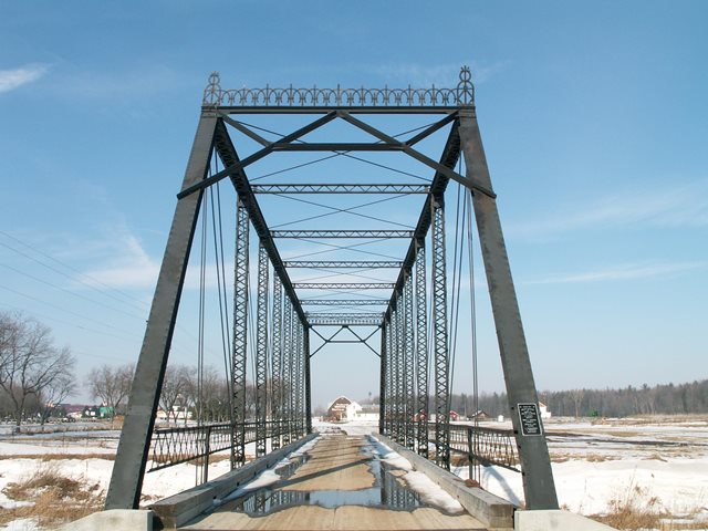
The Dehmel Road Bridge is a beautiful pin connected Pratt through truss. This bridge is known locally as the Black Bridge. It has been moved from its original location over the Cass River to the Zehnder Farm over Dead Creek, just east of M-83. This nine panel bridge was built in 1907 by the Joliet Bridge and Iron Company. It is 151 feet in length, 16 feet wide clearance, and 20 feet high (14 foot clearance). V-lacing is located on vertical members, sway bracing, and the bottom of the top chords. Portal bracing is of the a-frame design. Unusual, and beautiful portal cresting is located atop the portal bracing. Original lattice railings remain on the bridge. There is no original plaque on the bridge, however a new one has been placed, which lists the original date, builder, and county officials. Before being closed to vehicular traffic, the bridge had a weight limit posted at three tons. This bridge is similar to the two-span Smiths Crossing Bridge in Midland County except for number of spans. Smiths Crossing Bridge was also built in 1907.

At its original location on Dehmel Road, this bridge also had one pony truss approach span of 30 feet, meaning the whole bridge was once 181 feet long. This is interesting, since the nearby Beyer Road Bridge also has this through-pony combination. You don't usually find this setup in Michigan, and it is interesting to note that there were two bridges with this same configuration so close together. Also, before being moved, the Dehmel Road Bridge had modern Armco guardrails mounted below the original lattice railings. This was lucky, since usually the original railings were removed when new railings were added.
In 1982, the Dehmel Road Bridge was moved to the Zehnder Farm, east of Eischer Road and west of M-83. This allowed for the construction of a modern slab of concrete on Dehmel Road. It was not until 2002 that this bridge was placed on abutments at its current location, another part of the Zehnder Farm, just east of M-83.
The fact that this bridge has been saved, along with Beyer Road Bridge really says a lot of positive things about the Frankenmuth community. It seems like so often priority is given to preserving historic buildings in towns, but other areas of history, like bridges, are forgotten or ignored. This is not the case in Frankenmuth. There is a wide variety of history in Frankenmuth. So, if you visit Frankenmuth to enjoy some German heritage, be sure to stop and enjoy some transportation heritage as well!
This bridge is tagged with the following special condition(s): Reused
![]()
![]()
![]()
Coordinates (Latitude, Longitude):
Search For Additional Bridge Listings:
Bridgehunter.com: View listed bridges within 0.5 miles (0.8 kilometers) of this bridge.
Bridgehunter.com: View listed bridges within 10 miles (16 kilometers) of this bridge.
Additional Maps:
Google Streetview (If Available)
GeoHack (Additional Links and Coordinates)
Apple Maps (Via DuckDuckGo Search)
Apple Maps (Apple devices only)
Android: Open Location In Your Map or GPS App
Flickr Gallery (Find Nearby Photos)
Wikimedia Commons (Find Nearby Photos)
Directions Via Sygic For Android
Directions Via Sygic For iOS and Android Dolphin Browser
USGS National Map (United States Only)
Historical USGS Topo Maps (United States Only)
Historic Aerials (United States Only)
CalTopo Maps (United States Only)

© Copyright 2003-2024, HistoricBridges.org. All Rights Reserved. Disclaimer: HistoricBridges.org is a volunteer group of private citizens. HistoricBridges.org is NOT a government agency, does not represent or work with any governmental agencies, nor is it in any way associated with any government agency or any non-profit organization. While we strive for accuracy in our factual content, HistoricBridges.org offers no guarantee of accuracy. Information is provided "as is" without warranty of any kind, either expressed or implied. Information could include technical inaccuracies or errors of omission. Opinions and commentary are the opinions of the respective HistoricBridges.org member who made them and do not necessarily represent the views of anyone else, including any outside photographers whose images may appear on the page in which the commentary appears. HistoricBridges.org does not bear any responsibility for any consequences resulting from the use of this or any other HistoricBridges.org information. Owners and users of bridges have the responsibility of correctly following all applicable laws, rules, and regulations, regardless of any HistoricBridges.org information.
![]()