

View Information About HSR Ratings

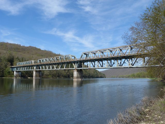
This is a very unusual and noteworthy bridge because the road runs through the middle of the three main truss spans, making the bridge half a deck truss and half a through truss. The unusual half-through design was done supposedly to give the roadway more clearance in the event of a flood, while also keeping the costs of pier construction low by preventing the need for tall piers to keep the roadway high. The through truss spans have a notable 30 degree skew. There also is a standard deck truss approach span for this bridge, and it is skewed at the end which meets the half-through truss spans, but not at the other end. As such, one side of the truss has an extra panel, seven panels on one side, and eight on the other. The bridge also has a couple stringer approach spans.
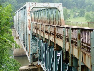
The unusual position of the road changed the way the bridge itself was configured. The portal bracing is small and compact above the roadway, a single solid built-up box beam, since there was no room for anything more extravagant like the heavy lattice portal bracing seen on other truss bridges from this period in Pennsylvania. Sway bracing above the roadway is omitted with the exception of the struts, which are alongside the lateral bracing, thereby keeping all overhead bracing confined within the top chord's footprint, which prevents any reduction of overhead clearance due to bracing. Underneath the bridge the rest of the sway bracing that stabilizes the structure can be found, and this bracing is arranged much like a deck truss. The railing system on the bridge is original and has no modern additions. This means that on the one side with a cantilevered sidewalk there is a railing on the sidewalk, but not along the truss line, while on the other side of the roadway a railing is positioned on the inside of the truss line.
The initial Historic Bridge Inventory failed to identify the significance of this bridge. Later, Pennsylvania opened its eyes to the obvious truth and declared the bridge eligible for listing on the National Register of Historic Places. This may not be enough to save the bridge from demolition and replacement, which is what PennDOT would prefer to do to this bridge as they develop a project for this crossing, the eligible listing has triggered Section 106 Historical Review, so PennDOT must at least first consider alternatives to demolition and replacement before it can move forward to demolish this bridge. If PennDOT does demolish this bridge it will be a devastating loss. It will result in the destruction of one of only two half-through truss bridges in Pennsylvania. Additionally, PennDOT has systematically been annihilating nearly historic highway bridge on two major Western Pennsylvania Rivers, the Allegheny and the Monongahela Rivers. At the turn of the 21st Century, these beautiful, scenic rivers were filled with numerous historic bridges, most of which were feasible to rehabilitate and preserve. However, one by one these bridges have been demolished and replaced with extremely ugly modern bridges with no heritage value. In addition, Forest County's historic metal truss bridge population has been hit particularly hard. The Hunter Station Bridge is one of the last two metal truss bridges in Forest County, and the only one currently eligible for or listed in the National Register of Historic Places.
![]()
![]()
![]()

![]()
![]()

![]()
![]()
![]()
This historic bridge has been demolished. This map is shown for reference purposes only.
Coordinates (Latitude, Longitude):
Search For Additional Bridge Listings:
Bridgehunter.com: View listed bridges within 0.5 miles (0.8 kilometers) of this bridge.
Bridgehunter.com: View listed bridges within 10 miles (16 kilometers) of this bridge.
Additional Maps:
Google Streetview (If Available)
GeoHack (Additional Links and Coordinates)
Apple Maps (Via DuckDuckGo Search)
Apple Maps (Apple devices only)
Android: Open Location In Your Map or GPS App
Flickr Gallery (Find Nearby Photos)
Wikimedia Commons (Find Nearby Photos)
Directions Via Sygic For Android
Directions Via Sygic For iOS and Android Dolphin Browser
USGS National Map (United States Only)
Historical USGS Topo Maps (United States Only)
Historic Aerials (United States Only)
CalTopo Maps (United States Only)

© Copyright 2003-2024, HistoricBridges.org. All Rights Reserved. Disclaimer: HistoricBridges.org is a volunteer group of private citizens. HistoricBridges.org is NOT a government agency, does not represent or work with any governmental agencies, nor is it in any way associated with any government agency or any non-profit organization. While we strive for accuracy in our factual content, HistoricBridges.org offers no guarantee of accuracy. Information is provided "as is" without warranty of any kind, either expressed or implied. Information could include technical inaccuracies or errors of omission. Opinions and commentary are the opinions of the respective HistoricBridges.org member who made them and do not necessarily represent the views of anyone else, including any outside photographers whose images may appear on the page in which the commentary appears. HistoricBridges.org does not bear any responsibility for any consequences resulting from the use of this or any other HistoricBridges.org information. Owners and users of bridges have the responsibility of correctly following all applicable laws, rules, and regulations, regardless of any HistoricBridges.org information.
![]()