

View Information About HSR Ratings
Most states by the 1920s had developed a number of standard plans for their truss bridges, and the bridge companies stopped having the role of designing the structure themselves, and rather had to follow state plans. The result is that between states, each state had its own design that could be found in various places throughout the state. It is easy to seen that this bridge is built to a standard plan, the same one as the Wilden Avenue Bridge. On the other hand, these standard plans took away the role of the bridge company, so identifying a bridge's builder based on the appearance of the bridge was no longer possible. This is all part of the evolution of bridge design that started with the beginning of the truss bridge era.
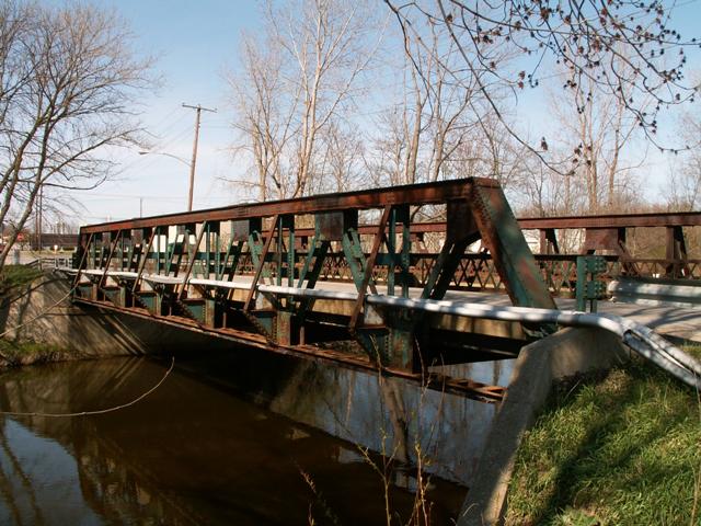
This bridge is a subdivided warren pony truss bridge with riveted connections. It retains original lattice guardrails. The bridge sits on concrete abutments. Rocker bearings are present at the south end of the bridge. The deck is concrete with an asphalt wearing surface. Concrete curbs are present on the bridge deck as well. Steel for the bridge was fabricated by the Bethlehem Steel Company, according to brands found on the bridge.
This bridge must have an interesting story behind it, because although rust is present all over the structure, there is clearly a lot more green paint on the western truss. It is like someone started to paint the bridge and then ran out of paint/money.
Information and Findings From DHPA Historic Bridge SurveyStatement of Significance The weight and varied size of the diagonals, the placement of the floor beams, and the integration of knee or external sway braces into the verticals mark a late stage in the design of all-riveted Warren pony trusses. This bridge retains its original members, including latticed guardrails. Architectural Description Concrete abutments and wingwalls support the one-span Warren pony truss. The riveted structure extends 84' in seven panels. Its all-interior verticals are manufactured from pairs of angles riveted to stay plates and reinforced with external sway bracing. Increasingly lighter toward midspan, the diagonals are made of a pair of angles (doubled in the outer panel) also riveted together with stay plates. The I floor beams are bolted to gussets and the verticals above the lower chord and carry the asphalt-over-concrete deck with its 22'3" roadway. Bridge Considered Historic By Survey: Yes |
This bridge is tagged with the following special condition(s): Unorganized Photos
![]()
![]()
![]()
![]()
This historic bridge has been demolished. This map is shown for reference purposes only.
Coordinates (Latitude, Longitude):
Search For Additional Bridge Listings:
Bridgehunter.com: View listed bridges within 0.5 miles (0.8 kilometers) of this bridge.
Bridgehunter.com: View listed bridges within 10 miles (16 kilometers) of this bridge.
Additional Maps:
Google Streetview (If Available)
GeoHack (Additional Links and Coordinates)
Apple Maps (Via DuckDuckGo Search)
Apple Maps (Apple devices only)
Android: Open Location In Your Map or GPS App
Flickr Gallery (Find Nearby Photos)
Wikimedia Commons (Find Nearby Photos)
Directions Via Sygic For Android
Directions Via Sygic For iOS and Android Dolphin Browser
USGS National Map (United States Only)
Historical USGS Topo Maps (United States Only)
Historic Aerials (United States Only)
CalTopo Maps (United States Only)

© Copyright 2003-2024, HistoricBridges.org. All Rights Reserved. Disclaimer: HistoricBridges.org is a volunteer group of private citizens. HistoricBridges.org is NOT a government agency, does not represent or work with any governmental agencies, nor is it in any way associated with any government agency or any non-profit organization. While we strive for accuracy in our factual content, HistoricBridges.org offers no guarantee of accuracy. Information is provided "as is" without warranty of any kind, either expressed or implied. Information could include technical inaccuracies or errors of omission. Opinions and commentary are the opinions of the respective HistoricBridges.org member who made them and do not necessarily represent the views of anyone else, including any outside photographers whose images may appear on the page in which the commentary appears. HistoricBridges.org does not bear any responsibility for any consequences resulting from the use of this or any other HistoricBridges.org information. Owners and users of bridges have the responsibility of correctly following all applicable laws, rules, and regulations, regardless of any HistoricBridges.org information.
![]()