

View Information About HSR Ratings
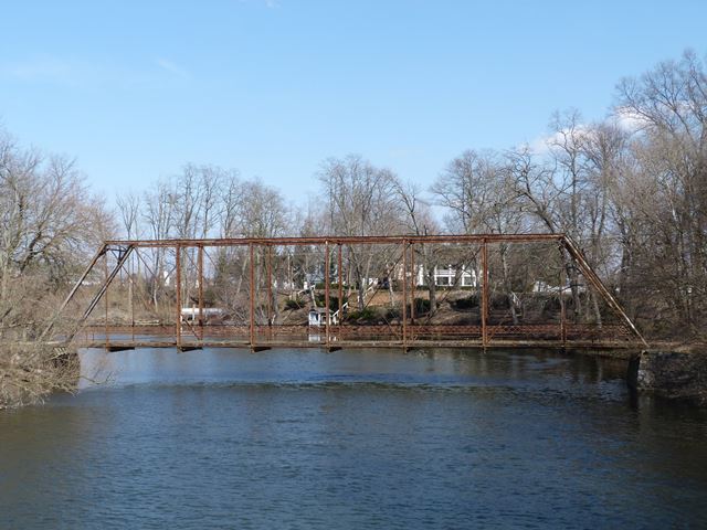
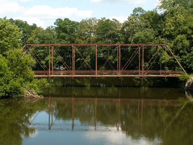
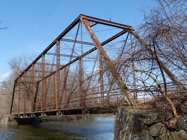
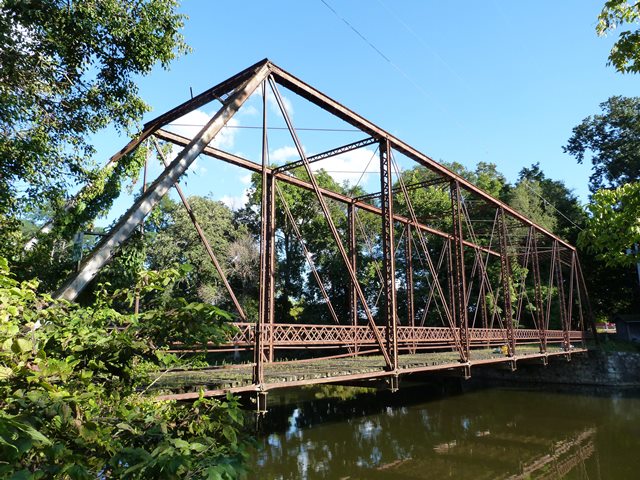
This bridge is an excellent and beautiful example of a pin-connected truss bridge in Michigan. It is noted for its fairly long span length of 139 feet. It also is largely unaltered from its original design and materials. The only thing missing is the builder plaques. The bridge retains a traditional design wooden deck and rests on random rubble type stone abutments. It has been closed to traffic for many years.
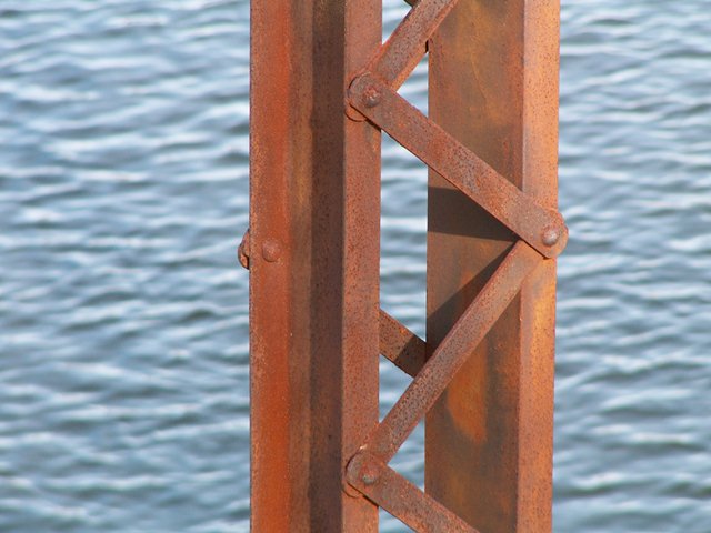
The Railroad Street Bridge is a Pratt through truss with pinned connections. Eyebars on the bridge are of the looped style. The bridge is composed of eight panels, and is a total of 139 feet in length. The bridge was built by the Massillon Bridge Company, of Massillon Ohio. The company ranked in second place for number of truss bridges built in Michigan. Railings on the bridge are original, but are a bit unusual. There is a standard lattice hub guard style railing on the bridge, but it is mounted higher than usual on the bridge. Below this railing there is a single strip of angle acting as a second section of railing. It is uncertain why the railings are like this. V-lacing is present on the bridge on the built-up vertical members, sway bracing, and under the upper chord. The portal bracing is a latticed design. Plaques do not remain on the bridge, although there was once one on an endpost, as well as on top of the portal bracing. The bridge is closed to traffic, and lattice guardrail had been welded onto the bridge to block cars. A local resident said that he thought the railing came from another truss bridge that is gone. Since no railing is missing on the Railroad Street Bridge, that makes sense. This local resident also pointed out that the wooden deck had been vandalized by kids in several spots. The bridge sits on stone abutments, which appear to be in good condition, but if they started to deteriorate, would present a danger to the bridge.
The exact date of construction for this bridge is unknown. MDOT lists a 1900 construction date, although a nearby resident HistoricBridges.org spoke with remembered the plaque as having a late 1800s date on it. The resident is more likely correct: 1900 is a default date used in the MDOT Historic Bridge Inventory when the surveyors did not know when a really old bridge was built. Another online source claimed that the bridge was built in 1873. This is most certainly incorrect, since a pin-connected Pratt truss bridge of traditional composition would not have been built in 1873. A bridge may have been built here in 1873, but it was not the bridge seen today. The bridge is a style that the Massillon Bridge Company built from roughly 1895 to 1907. The Marantette Bridge also has "Jones and Laughlins" brands on some of the metal of the bridge, indicating what mill produced the metal. Jones and Laughlins dropped the "s" from their name around 1905, so this suggests that the Marantette Bridge is older than 1905.
The Marantette Bridge is named after a noteworthy family in the area, whose large house is immediately southeast of the bridge.
MDOT incorrectly lists this bridge as being on Buckner Road. Buckner Road does not run south of the village of Mendon. This bridge is mostly in village limits, and as such is known as the Railroad Street Bridge, or locally as the Marantette Bridge. Outside village limits, the road ends at a "T" intersection, but another road nearby is named Bucknell Road, leading south away from the bridge.
This bridge is in an un-restored condition. It sits in its original location in a park setting, a DNR boat launch site. While overall, the bridge's metal is in good condition, there is unusually heavy section loss at the bottom chord connections including the eyebar heads. This is a typical area of deterioration, but on this bridge it is particularly extensive, while in contrast elsewhere there is little deterioration. One exception is at the ends of the sway bracing where section loss was observed. The abutments may also present a danger to the bridge itself, if they start to deteriorate. The abutments are composed of random rubble stones, something that was used often in Michigan. A far cry from the nearly indestructible ashlar found in states like Pennsylvania, such random rubble abutments composed of randomly shaped rocks creatively stacked upon one another rely strongly on mortar which on abandoned bridges is not maintained. A number of truss bridges in Michigan have been lost because of the abutments crumbling. The wooden deck needs work also, to keep the bridge around as a viable pedestrian crossing. This shows up as the last through truss in St. Joseph County, so the bridge is locally significant. The bridge is significant on a statewide and national scale as one of a rapidly shrinking number of through truss bridges. With its original guardrails, it also retains a good degree of integrity.
Covered bridges get a lot more attention and a lot more care than historic metal truss bridges like the Railroad Street Bridge. This is why HistoricBridges.org excludes covered bridges from its listings: to shine the spotlight on the rest of the historic bridge types that so many people do not pay attention to. The Railroad Street Bridge is only 4.3 straight line miles from a historic covered bridge. Comparing these two bridges provides a demonstration of typical historic bridge practice found nationwide. See the MDOT page for a photo of the covered bridge, and then see the table of comparisons below.
|
Covered Bridge on Covered Bridge Road Restoration done, including painting. |
Metal Truss Bridge on Railroad Street No restoration done, no paint on bridge. |
Both bridges are clearly historic, but only the covered bridge has been treated as historic. This problem is repeated across the country. One of the problems here is the fact that the government created a program to preserve covered bridges, and only covered bridges. This is absolutely absurd, because other bridge types may have greater historic significance, or be otherwise aesthetically or geographically suited for preservation. Local bridge owners often choose to demolish truss bridges because the only federal and state money provided to them is for replacement not repair or restoration. Having a covered bridge program suggests that the government thought that only covered bridges deserved to be preserved. Instead, the government should have created a program to provide funding for any bridge that is eligible for the national register of historic places.
What is the cost of this unjust system for bridge preservation? Potentially any truss bridge that has been demolished, as well as other historic bridge types, such as concrete girder and arch bridges.
The Railroad Street Bridge and the covered bridge on Covered Bridge Road stand together as a perfect demonstration of how historic bridges, and the people who appreciate them, have been discriminated against. The tragedy is that by the time anyone fixes this problem, it will likely be too late for the majority of this country's historic bridges. However, it is still worth fighting for those historic bridges that remain.
This bridge is tagged with the following special condition(s): Available and Unorganized Photos
![]()
![]()
![]()
![]()
![]()
![]()
![]()
![]()
![]()
Coordinates (Latitude, Longitude):
Search For Additional Bridge Listings:
Bridgehunter.com: View listed bridges within 0.5 miles (0.8 kilometers) of this bridge.
Bridgehunter.com: View listed bridges within 10 miles (16 kilometers) of this bridge.
Additional Maps:
Google Streetview (If Available)
GeoHack (Additional Links and Coordinates)
Apple Maps (Via DuckDuckGo Search)
Apple Maps (Apple devices only)
Android: Open Location In Your Map or GPS App
Flickr Gallery (Find Nearby Photos)
Wikimedia Commons (Find Nearby Photos)
Directions Via Sygic For Android
Directions Via Sygic For iOS and Android Dolphin Browser
USGS National Map (United States Only)
Historical USGS Topo Maps (United States Only)
Historic Aerials (United States Only)
CalTopo Maps (United States Only)

© Copyright 2003-2024, HistoricBridges.org. All Rights Reserved. Disclaimer: HistoricBridges.org is a volunteer group of private citizens. HistoricBridges.org is NOT a government agency, does not represent or work with any governmental agencies, nor is it in any way associated with any government agency or any non-profit organization. While we strive for accuracy in our factual content, HistoricBridges.org offers no guarantee of accuracy. Information is provided "as is" without warranty of any kind, either expressed or implied. Information could include technical inaccuracies or errors of omission. Opinions and commentary are the opinions of the respective HistoricBridges.org member who made them and do not necessarily represent the views of anyone else, including any outside photographers whose images may appear on the page in which the commentary appears. HistoricBridges.org does not bear any responsibility for any consequences resulting from the use of this or any other HistoricBridges.org information. Owners and users of bridges have the responsibility of correctly following all applicable laws, rules, and regulations, regardless of any HistoricBridges.org information.
![]()