

View Information About HSR Ratings
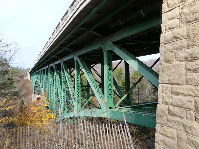
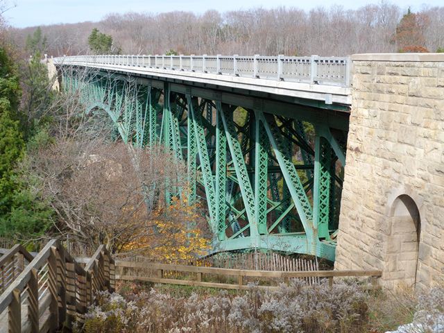
Among Michigan's largest and most well-known historic bridges is the iconic Cut River Bridge, which is listed on the National Register of Historic Places. This bridge is large enough that MDOT actually has maintained this bridge as an area attraction. Surrounding the bridge is a roadside park and a series of trails around the bridge. The intent to make this bridge something more than just a crossing goes back before this bridge's status as a historic bridge to its initial construction. The bridge was designed as an attraction even when it was built, since sidewalks above the bridge in this rural area are present. Also, a set of stairways, part of the original design, take pedestrians under the bridge where they can view the supporting trusses. The abutments and piers were also given unusually exceptional detail, in particular the use of decorative stone facing. The two main piers give the appearance are attractive cut stone arches.
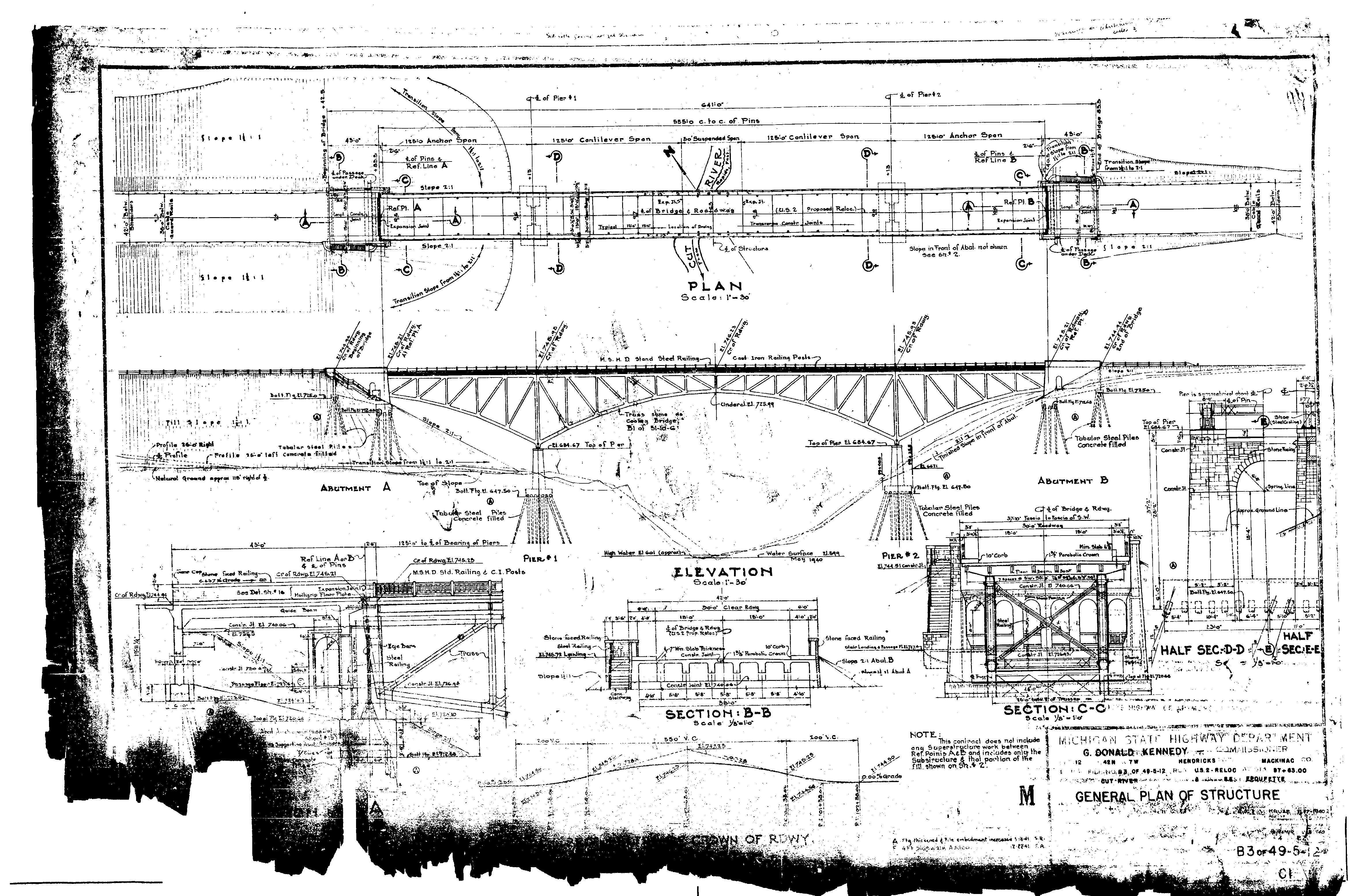
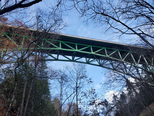
The bridge includes a total of 888 tons of steel and its height over the Cut River is 147 feet. It offers views of Lake Michigan from its deck. The bridge was originally painted a silver color, but is today painted green. This bridge is a steel deck cantilever truss bridge. This structure type is much more common in more hilly states like Pennsylvania, but is extremely rare in Michigan. The structure has visual complexity as a result of the extensive lattice and v-lacing on its riveted, built-up members, which are all very massive, typical for both a bridge of its size and its age. The bridge retains original standard-plan metal guardrails (Michigan's "signature" type R4 railings) on the sidewalks that flank the roadway on each side. It also retains standard Michigan State Highway Department plaques.
The cantilever truss is configured to include a small suspended span, which is carefully designed to match the shape of the cantilever arms. The suspended span which consists of the center two panels of the bridge, can be identified by small pins and hinges at the far ends of those panels. Bridge visitors who walk down the stairway and under the bridge can take a close look at the ends of the bridge and see how cantilever truss bridges function in a fashion unlike typical simple span bridges. Bridges have abutments, and usually the ends of the bridge sit, or bear, directly on the abutments, transferring their weight down into the abutment. However, with the Cut River Bridge, this is not the case. Visitors will not find a heavy steel bridge bearing assembly on the abutment. Instead, the end of the bridge is connected to the abutment and the end of the truss have pins that are connected by an eyebar. Eyebars are suited for tension forces, not compression forces. The reality with the Cut River Bridge is that this is not a bearing, is is instead an anchorage, and any forces between the bridge and abutment should be tension, meaning the bridge can pull upward on the abutment, and is not pushing its weight down. This function exists because the ends of the bridge are anchor arms of the cantilever truss bridge. The anchor arms function like holding one of your arms outstretched: the support for the bridge comes from the center, which is the piers. Support for the bridge's weight at the end of the abutments is not needed, because the cantilever arm portion of the bridge works with the anchor arm to balance and hold the weight over the pier. Given this function, the piers have particularly large and massive bearings, since this is where the weight of the bridge and its loads are being delivered.
The bridge also has a concrete t-beam approach span at each end. These spans are concealed within the abutments for the bridge. This unusual detail is partly because the abutments serve the ends of the truss spans as well as the ends of the bridge proper, and also appears to be partly because of the walkway under the bridge that makes use of the abutment as well between the ends of the truss and the bridge proper. Covering up the t-beam spans by extending the abutment walls was likely done for aesthetic reasons. To visitors, it looks like the end of the truss spans is also the end of the bridge proper.
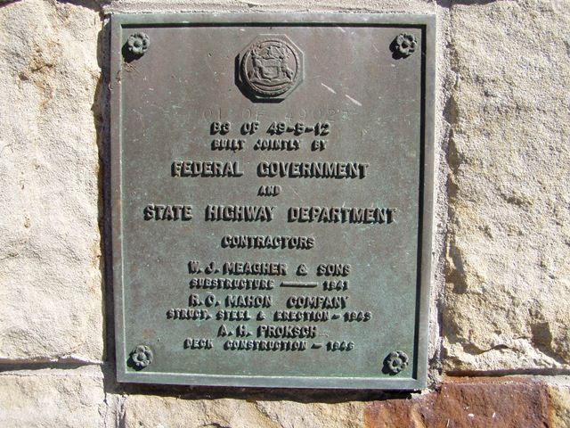
It is interesting to note that the dates for construction of the different parts have a difference of five years, which seems like a very long time, even for a bridge of this size. There is a reason for this. The dates of construction range from 1941 to 1946, which encompassed World War II. Due to the demand of steel for the war, construction on the bridge was halted during the war. While construction halted, people could take a trail to get out to the bridge and view the giant bridge which was at the time in the middle of nowhere. Several contractors were involved with the construction of the bridge. Three of the involved contractors are listed on the plaque, and due to the unusual construction schedule for this bridge, each contractor listing also includes a date in which they were involved with the work. W. J. Meagher and Sons built the substructure in 1941. R. C. Mahon Company was the on-site contractor for the structural steel and its erection in 1943. A. H. Proksch of Iron River, Michigan constructed the deck in 1946. Oddly, the plaque does not credit the company that actually fabricated the steel trusses, which was the regionally prolific Wisconsin Bridge and Iron Company of Milwaukee, Wisconsin. As the fabricator, the company also drew up all the original shop drawings for the bridge upon which the company's name appears.
The bridge was designed in-house by the Michigan State Highway Department, using the slightly older and extremely similar Mortimer E. Cooley Bridge as a guide. It is somewhat unusual that these two different large bridges in completely different locations each have exactly the same span length. An overview sheet of plans for the Cut River Bridge actually has a notation reading "Truss same as Cooley Bridge B1 of 31-10-6."
Many visitors will find that Cut River to not be much of a river, or even a creek; this bridge would be more aptly named Cut Valley Bridge. The bridge is really taking the road over the valley more so than the river. It should be noted that local residents have informed HistoricBridges.org that during flood events, Cut River does become something more worthy of being called a river.
This bridge is tagged with the following special condition(s): Unorganized Photos
![]()
![]()
![]()
![]()
![]()
![]()
![]()
Coordinates (Latitude, Longitude):
Search For Additional Bridge Listings:
Bridgehunter.com: View listed bridges within 0.5 miles (0.8 kilometers) of this bridge.
Bridgehunter.com: View listed bridges within 10 miles (16 kilometers) of this bridge.
Additional Maps:
Google Streetview (If Available)
GeoHack (Additional Links and Coordinates)
Apple Maps (Via DuckDuckGo Search)
Apple Maps (Apple devices only)
Android: Open Location In Your Map or GPS App
Flickr Gallery (Find Nearby Photos)
Wikimedia Commons (Find Nearby Photos)
Directions Via Sygic For Android
Directions Via Sygic For iOS and Android Dolphin Browser
USGS National Map (United States Only)
Historical USGS Topo Maps (United States Only)
Historic Aerials (United States Only)
CalTopo Maps (United States Only)

© Copyright 2003-2024, HistoricBridges.org. All Rights Reserved. Disclaimer: HistoricBridges.org is a volunteer group of private citizens. HistoricBridges.org is NOT a government agency, does not represent or work with any governmental agencies, nor is it in any way associated with any government agency or any non-profit organization. While we strive for accuracy in our factual content, HistoricBridges.org offers no guarantee of accuracy. Information is provided "as is" without warranty of any kind, either expressed or implied. Information could include technical inaccuracies or errors of omission. Opinions and commentary are the opinions of the respective HistoricBridges.org member who made them and do not necessarily represent the views of anyone else, including any outside photographers whose images may appear on the page in which the commentary appears. HistoricBridges.org does not bear any responsibility for any consequences resulting from the use of this or any other HistoricBridges.org information. Owners and users of bridges have the responsibility of correctly following all applicable laws, rules, and regulations, regardless of any HistoricBridges.org information.
![]()