The railway crossing over River Tay at Dundee is one of the most infamous
crossings in the United Kingdom
because the previous bridge at this location collapsed,
causing total loss of life of a train on the bridge at the time of the collapse.
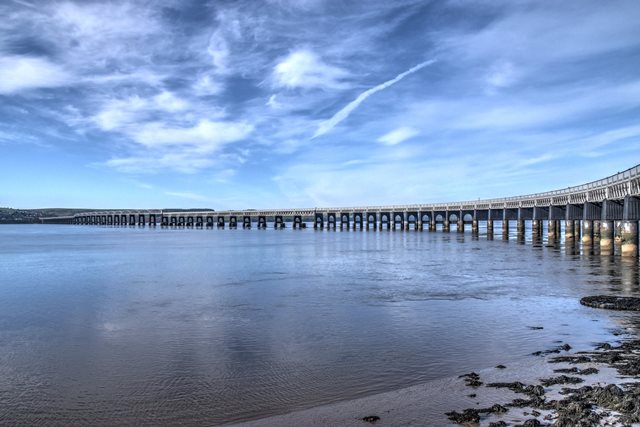
This bridge is the structure which replaced that ill-fated bridge. This
replacement bridge has a much more positive history, and is today a very
important historic bridge, due to its incredible length. Environment Scotland
even suggests this may be the longest wrought iron bridge in the world!
The bridge consists of a variety of spans. The wrought iron spans come in a
variety of forms as follows. From north to south, there are deck truss spans
that later (meaning not original to this bridge) had unusual inverted bowstring
trusses cantilevered off the edges of them to provide room for a station. Next,
there are two beautiful deck arch spans over the road. The river spans follow,
starting with "short" deck truss spans of about 70 feet each. Closer to the
center of the bridge the short deck truss spans give way to longer deck truss
spans, of 129 feet each, leading to the main through truss bowstring spans,
which include lengths of 245 and 227 feet. The south end of the bridge has more
deck truss spans, lengths from 129 and 145 feet. The northern portion of this
bridge features a sweeping curve.
The deck truss spans of this bridge consist of the outer truss lines being
salvaged and reused from the first, collapsed bridge, with an additional two
truss lines added to the interior when this bridge was constructed. Thus, some
parts of this bridge in fact date to 1878.
The inverted bowstring spans, shown above, have Hallside on the lower chord. However, since
these spans are additions to the original bridge, there may have been additional
mills which supplied materials for this bridge, but this was the span close
enough for inspecting.
Above: The arch spans feature a different paint scheme.
Above: Photo showing the collapse of the previous bridge.
Above: Photo showing the collapse of the previous bridge.
Above: William Henry Barlow
Official Heritage Listing Information and Findings
Listed At: Category A
Discussion:
Historic Environment Scotland Number: LB25681
Canmore ID: 31692
Site Number: NO32NE 11
Description William Henry Barlow, 1882-87,
incorporating parts of the first Tay Bridge by Sir Thomas Bouch, 1871-7.
Contractors for the first bridge were Charles de Bergue and Co and
Hopkinson Gilkes and Co; and for the second, William Arrol and Co.
Railway viaduct principally of wrought-iron. Listing covers the full
10,711-feet (3.264km) length of the bridge, including brick viaducts at
Newport and Dundee ends and the downstream piers of the first bridge.
From S to N.
a) WORMIT: 4 brick arches and piers, 50' spans,
widening to S for diversion of lines to Newport and Edinburgh.
b)
SOUTH APPROACH, piers 4-28 are twin wrought-iron cylinders lined with
brickwork and filled with concrete below water level. Connecting tie of
cast and wrought-iron, brick and concrete at high water level. Hollow
superstructure of octagonal wrought-iron plate piers linked by an arch.
Girders spanning 129 and 145 feet, arranged in 4s, Barlow's 2 new
girders sandwiched between Bouch's re-used girders. Both types are of
double-triangular wrought-iron. Corrugated-iron and steel decking.
Wrought-iron lattice parapet with wooden rail.
c) NAVIGATION
SPANS, 13 spans of 245 and 227 feet, on a similar substructure to that
of the South Approach. Parabolic hog-backed girders (all by Arrol),
above track level give a clearance for ships of 77 feet. Cast-iron
segmental arches on cast-iron piers with dated plaques at entrances to
navigation sections.
d) NORTH APPROACH, gradient falling towards
Dundee, has 37 spans, Nos 42-53 similar to the South Approach. Nos 54-77
curve towards the station, having narrower spans on trabeated cast-iron
piers filled with brick and concrete.
e) ESPLANADE SECTION, piers
78-85: 2 wrought-iron skew arches on brick piers over Riverside Drive,
then 4 spans of wrought-iron girders on cast-iron columns, grouped in
4s. Later fish-bellied girders cantilevered out to carry station
platform.
f) BR DIVISION CIVIL ENGINEER, TAYBRIDGE, OFFICE AND
WORKSHOPS (excluding modern building at track level), late 19th century,
in place of 100-foot hog-backed girder over original Esplanade. 3 wide
arches, red brick with yellow brick bands to N and S elevations.
Wrought-iron footbridge on cast-iron columns approaches pedestrian
subway.
g) VIADUCT of original bridge inclines to ground level on
34 arches and a ramp. W-most arch has a parapet.
Statement of
Special Interest The longest bridge in Britain and perhaps the
biggest wrought-iron structure in the world. The high girders of the
first bridge blew down on 28.12.1879.
Original / Full Size Photos A collection of overview photos that show the bridge as a whole and general areas of the bridge. This gallery offers photos in the highest available resolution and file size in a touch-friendly popup viewer. Alternatively, Browse Without Using Viewer
Original / Full Size Photos A collection of detail photos that document the parts, construction, and condition of the bridge. This gallery offers photos in the highest available resolution and file size in a touch-friendly popup viewer. Alternatively, Browse Without Using Viewer
Mobile Optimized Photos A collection of overview photos that show the bridge as a whole and general areas of the bridge. This gallery features data-friendly, fast-loading photos in a touch-friendly popup viewer. Alternatively, Browse Without Using Viewer
Mobile Optimized Photos A collection of detail photos that document the parts, construction, and condition of the bridge. This gallery features data-friendly, fast-loading photos in a touch-friendly popup viewer. Alternatively, Browse Without Using Viewer