Official Heritage Listing Information and Findings
Listed At: Category B (Bridge House), Bridge is
Scheduled Ancient Monument, # 3447
Discussion (Bridge): (Institute Civil Engineers
Historic Engineering Works no. HEW 0084/05)
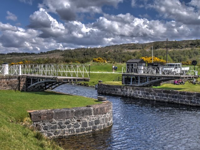
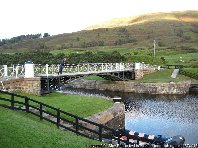
Moy Turn-bridge (aka
a swing bridge)
When planning the canal Telford and Jessop
decided to adopt cast-iron turn-bridges, a development of those
introduced at the London and West India Docks by 1805. Of several
turn-bridges installed over the canal, only that at Moy now remains.
Moy Bridge, erected in 1820, has a span of 40 ft and is 10 ft wide.
The ironwork was cast in Wales at the foundry of William Hazledine of
Plas Kynaston and the original square-headed nuts and bolts of the
period can be inspected. An engraved plan and section exists and a
drawing by Thomas Rhodes of a timber version, but Telford stated that
all the bridges on the canal were cast iron except the lock-gate
footbridges.
The bridge comprises two counter-balanced arms
pivoting on horizontal bearings with their ends meeting at mid-span to
allow road traffic to cross. Until refurbishment in 1995, the
counter-balance weights in the back of the frame above the bearings
consisted of 3 ft long Jessop plate-rails formerly used for transporting
spoil when cutting the canal, one of which is preserved in the ICE
Museum at Heriot-Watt University.
The bridge is operated by hand
from each side and until recently the bridge keeper had to row across
the canal each time the bridge was opened or closed.
R Paxton and
J Shipway, 2007.
Reproduced from 'Civil Engineering heritage:
Scotland - Highlands and Islands' with kind permission from Thomas
Telford Publishers.
Discussion (Bridge House)
Description
Circa 1820. Single-storey, 3-bay
symmetrical cottage, with central painted, corrugated iron porch, facing
canal and adjacent to swing bridge (Scheduled Monument No 3447). Harled,
lined out to west gable. Single window to each gable. Extension to rear
with entrance door. Rectangular-plan garden to west of cottage enclosed
by coped drystone wall.
Replacement 3-pane glazing in timber sash
and case frames. 4-pane glazing in fixed timber frames to porch. End
stacks with clay cans. Pitched, slate roof.
The interior was seen
in 2013. The plan form of 2 principal rooms flanking a central hall is
largely as original, with later kitchen to rear. Some simple cornicing.
Slatted timber doors.
Statement of Special Interest
This
former bridge keeper's cottage is likely to date 1820, when Moy Swing
Bridge was constructed to provide access to Moy Farm which is still
extant to the northeast. The isolated setting of Moy Bridge Cottage with
bridge and garden has not changed greatly since it was built and adds
interest to the building as an indication of its former functional
relationship. The cottage is a good example of a bridge keeper's cottage
with a single window to each gable for views along the canal of
approaching traffic. Bridge keeper's cottages are an integral and
important part of the Caledonian Canal, which at the time of its
construction was the largest canal in the United Kingdom.
The
whole of the Caledonian Canal is a Scheduled Monument which identifies
it as being of national importance to Scotland. For this section of the
Caledonian Canal see Scheduled Monument No 6492, 3447 and 2500.
The primary role of a bridge keeper was to maintain and operate the
swing bridges and cottages were constructed adjacent to the bridge for
convenience. Cottages were usually single storey with accommodation
comprised of a living room and a bedroom, and sometimes with a small
outshot to the rear, used as a scullery. As living standards improved
these outshots have generally been enlarged for increased kitchen and
bathroom accommodation, and this is evident at Moy Bridge Cottage. The
cottages were often set in garden to grow vegetables and keep poultry
and animals.
When planning the canal Thomas Telford decided to
use a cast-iron swing bridge of a design similar to that used at the
London and West India Docks of 1805. Although several swing bridges of
this type were constructed, Moy Swing Bridge (Scheduled Monument No
3447) is the only original surviving swing bridge on the Caledonian
Canal. It is still hand operated using the original winch and mechanism.
The ironwork was cast at the foundry of William Hazledine in Plas
Kynaston, Wales. The bridge swings in two halves and until recently the
bridge keeper had to row across the canal each time the bridge was in
operation to open the off-side leaf.
The Caledonian Canal is one
of five canals surviving in Scotland but is unique among them as being
the only one entirely funded by public money. The canal was part of a
wider infrastructure initiative across the Highlands to facilitate trade
and the growth of industry and, most importantly for the Government, to
tackle the emigration problem resulting from the Highland Clearances, by
providing much-needed employment. The experienced engineer Thomas
Telford submitted a report in 1802 to Government commissioners which
detailed the route and size of the canal. The canal connects Inverness
in the north to Corpach, near Fort William in the west, by linking four
lochs: Loch Dochfur, Loch Ness, Loch Oich and Loch Lochy. The total
length of the canal is 60 miles, but only 22 miles are man-made.
Built to take sea-going ships, including the 32-gun and 44-gun frigates
of the Royal Navy, the Caledonian Canal was designed on a much larger
scale than other canals in Britain and the locks were the largest ever
constructed at that time. This combined with the remoteness of the
location and the variable ground conditions, make it a great feat of
engineering and construction.
Telford was appointed principal
engineer to the commission with William Jessop as consulting engineer.
Although work began in 1804 rising costs and the scale of the project
resulted in slow progress and the first complete journey was made on
23-24 October 1822. Whilst the canal was constructed for commercial use
it was never a commercial success. Since its opening it was beset by
problems and had to be closed for repairs and improvements in the 1840s.
However the canal became popular with passenger steamers with tourism
increasing following a visit by Queen Victoria on 16 September 1873.
Listed building record updated as part of the Scottish Canals estate
review (2013-14).
References
Bibliography
Hume, J. (1977)
The Industrial Archaeology of Scotland Volume 2: p.202.
Paxton,
R. & Shipway, J. (2007) Civil Engineering Heritage: Scotland - Highlands
and Islands. London. pp 160-1.
Miers, M (2008) The Western
Seaboard: An Illustrated Architectural Guide. Rutland Press. p29.
Canmore ID: 23745 (Bridge)
Site Number: NH73SE 29
|