

View Information About HSR Ratings
Cầu Sêrêpôk refers to what is today three bridges. Two bridges carry traffic today: a historic steel truss bridge carries westbound traffic, while immediately to the south, a modern bridge carries eastbound traffic. Immediately south of these two bridges is the third bridge, which is the original bridge here, which is today closed to traffic but left standing presumably for its heritage value. This page discusses this closed bridge.
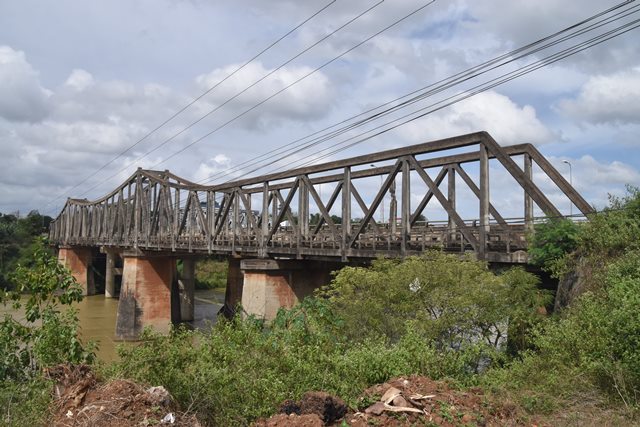
Very little is known about this bridge and its history. Reportedly, this bridge was built by the French government in 1941. The bridge lengths and widths given are rough estimates. The bridge has a very narrow roadway. This concrete truss bridge has the shape and appearance of a cantilever truss bridge, but it is perhaps better described as a continuous truss bridge. The bridge span layout is asymmetrical, because instead of the three main spans typically found with continuous/cantilever bridges, there is an additional span that is part of the single continuous truss unit located at the east end of the bridge. This extra eastern span has parallel top and bottom chords, meaning the slope of the top chord seen in the other spans levels off before the easternmost span.
Concrete truss bridges are one of the most rare bridge types in the world. Concrete simply never became a popular material for constructing truss bridges. Continuous and/or cantilever concrete truss bridges are an even more rare subcategory of concrete truss bridge. There are at least three bridges of this type that have been built in Vietnam. One was destroyed with some remnants surviving today. Another, Cầu Cai Lậy, crosses the Ba Rai River in Tien Giang province. Unidentified historical photos further suggest there was at least one more bridge in addition to these three, and it is quite likely there may be more unaccounted examples, which may or may not survive today. Although all three bridges noted above are rare examples of continuous concrete truss bridges, the exact design details of each of these bridges varies, meaning these were not a "standard" bridge design in Vietnam. In any case, each surviving bridge is a rare and highly significant historic bridge, a bridge type that many countries do not have a single example of.
The abandoned bridge has severe deterioration in some members, and some members are actually broken. Despite this, the overall bridge remains standing, and aside from the deterioration, the bridge appears to be unaltered from its original design and retains its original material.
![]()
![]()
![]()
Coordinates (Latitude, Longitude):
Search For Additional Bridge Listings:
Additional Maps:
Google Streetview (If Available)
GeoHack (Additional Links and Coordinates)
Apple Maps (Via DuckDuckGo Search)
Apple Maps (Apple devices only)
Android: Open Location In Your Map or GPS App
Flickr Gallery (Find Nearby Photos)
Wikimedia Commons (Find Nearby Photos)
Directions Via Sygic For Android
Directions Via Sygic For iOS and Android Dolphin Browser

© Copyright 2003-2024, HistoricBridges.org. All Rights Reserved. Disclaimer: HistoricBridges.org is a volunteer group of private citizens. HistoricBridges.org is NOT a government agency, does not represent or work with any governmental agencies, nor is it in any way associated with any government agency or any non-profit organization. While we strive for accuracy in our factual content, HistoricBridges.org offers no guarantee of accuracy. Information is provided "as is" without warranty of any kind, either expressed or implied. Information could include technical inaccuracies or errors of omission. Opinions and commentary are the opinions of the respective HistoricBridges.org member who made them and do not necessarily represent the views of anyone else, including any outside photographers whose images may appear on the page in which the commentary appears. HistoricBridges.org does not bear any responsibility for any consequences resulting from the use of this or any other HistoricBridges.org information. Owners and users of bridges have the responsibility of correctly following all applicable laws, rules, and regulations, regardless of any HistoricBridges.org information.
![]()