

View Information About HSR Ratings

This was the first highway bridge over the Columbia River in the United States. It was built to carry not only vehicular traffic, but also a water pipeline. Although the bridge roadway has today been converted for pedestrian use only, it continues to carry a water pipeline, although this pipeline is not the original pipe and is much larger than the original.
The bridge was financed and built for private interests who organized as the Washington Bridge Company. It is not known who the actual on-site contractors were. Construction began in February 1906 and the bridge was open to traffic in February 1908. However the bridge was purchased by the Washington State Highway Board in 1909, only a year after the bridge was built, as the state felt the bridge was very valuable to the area and a worthwhile public investment. The cost of constructing the bridge was $178,233.07 and the state purchased the bridge for $182,207.55. The Wenatchee Reclamation District in turn purchased the bridge from the state after the nearby George Sellar Bridge was completed to provide a new vehicular crossing. The Wenatchee Reclamation District replaced the original pipes with a larger pipe resting inside the truss lines and also left the bridge open for pedestrians only. In 2008 the bridge was rehabilitated for continued pedestrian use. The pipeline remains as well and continues to function by providing water for the East Wenatchee fruit industry.
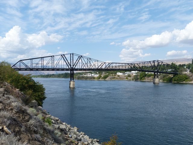
The bridge is a fully pin-connected cantilever through truss. The suspended span is a ten panel Baltimore through truss, and the cantilever and anchor arms also follow a Baltimore truss configuration. The entire cantilever truss portion contains fifty panels, eight panels in each cantilever arm and twelve panels in each anchor arm. The entire top chord of the cantilever arms is eyebar, while only two panels near the main post of the anchor arms are eyebar, the remainder being built-up box beam. The bridge has a very complex design that gives it an amazing sense of variety. Built-up beams on the trusses and the bracing take a wide variety of sizes and configurations, with details like v-lacing, lattice, and battens found throughout the bridge's built-up beams.
The bridge's cantilever truss consists of anchor arms that each have a length of 240 feet, with each of the cantilever arms being 160 feet. The cantilever arms hold a 200 foot long suspended span in the center. This adds up to a total length for the truss of 1,000 feet. Additionally, at the west end of the bridge there is a 60 foot plate girder span. As originally built, the bridge had a timber approach system at the western end of 565.7 feet, which gave the original bridge a total length of 1,625.7 feet. Today, the timber approach system has been replaced with a spiral-like curved pedestrian walkway ramp, and as such the bridge today has a roughly estimated total length of 1,320 feet. As originally built, the bridge has a 20.5 foot roadway and the highway roadway was designed to accommodate a street railway as well. The original water pipes on the bridge were two pipes with four feet inside diameter mounted on brackets outside of the truss lines. 1,100 tons of steel were used to build the bridge (1,040 tons for the cantilever truss alone).
This is a bridge of extremely high historic significance. It is one of the oldest known surviving highway cantilever through truss bridges in the United States. It was completed a year before the landmark cantilever truss in New York City, the Queensboro Bridge. Cantilever truss bridges represent the longest of truss bridge spans and the most complex of truss bridge designs, and as such are significant engineering achievements, with this bridge having all that significance in addition to the age of the bridge. The bridge is also significant for its role in promoting the development of East Wenatchee and the surrounding region by bringing water from the Wenatchee River to this region for orchards. It is also impressive and noteworthy that this was the first highway bridge over the Columbia River in the United States and that a bridge that has that distinction would still survive today.
This bridge is an outstanding example of historic truss bridge preservation, and an exceedingly rare example of a large span cantilever truss bridge being preserved for non-motorized use. Cantilever truss bridges are some of the most amazing engineering achievements in the country, yet because of their size and thus high cost of preservation, few have been preserved for pedestrian use.
A new ramp was constructed at the western end of the bridge for the use of non-motorized traffic. The bridge trusses remain largely unaltered from their original design, making the historic integrity of the truss excellent. The only major alteration to the truss spans is the removal of the original pipe brackets and reconfiguration of the pipe system to one large pipe resting inside the truss lines. During the field visit to the bridge, the paint system of the bridge was found to be in excellent condition.
![]()
![]()

![]()
![]()
![]()
Coordinates (Latitude, Longitude):
Search For Additional Bridge Listings:
Bridgehunter.com: View listed bridges within 0.5 miles (0.8 kilometers) of this bridge.
Bridgehunter.com: View listed bridges within 10 miles (16 kilometers) of this bridge.
Additional Maps:
Google Streetview (If Available)
GeoHack (Additional Links and Coordinates)
Apple Maps (Via DuckDuckGo Search)
Apple Maps (Apple devices only)
Android: Open Location In Your Map or GPS App
Flickr Gallery (Find Nearby Photos)
Wikimedia Commons (Find Nearby Photos)
Directions Via Sygic For Android
Directions Via Sygic For iOS and Android Dolphin Browser
USGS National Map (United States Only)
Historical USGS Topo Maps (United States Only)
Historic Aerials (United States Only)
CalTopo Maps (United States Only)

© Copyright 2003-2024, HistoricBridges.org. All Rights Reserved. Disclaimer: HistoricBridges.org is a volunteer group of private citizens. HistoricBridges.org is NOT a government agency, does not represent or work with any governmental agencies, nor is it in any way associated with any government agency or any non-profit organization. While we strive for accuracy in our factual content, HistoricBridges.org offers no guarantee of accuracy. Information is provided "as is" without warranty of any kind, either expressed or implied. Information could include technical inaccuracies or errors of omission. Opinions and commentary are the opinions of the respective HistoricBridges.org member who made them and do not necessarily represent the views of anyone else, including any outside photographers whose images may appear on the page in which the commentary appears. HistoricBridges.org does not bear any responsibility for any consequences resulting from the use of this or any other HistoricBridges.org information. Owners and users of bridges have the responsibility of correctly following all applicable laws, rules, and regulations, regardless of any HistoricBridges.org information.
![]()