

View Information About HSR Ratings
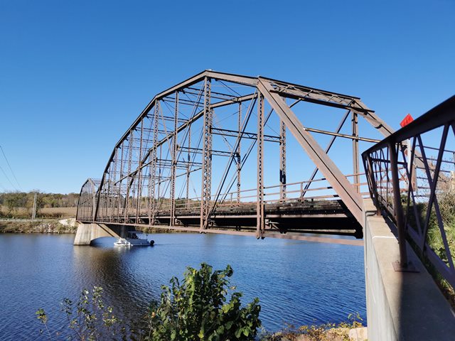
Rare in any state, this truly unique bridge in Wisconsin's small surviving population of historic highway bridges was nevertheless sentenced to the dumpster. Demolition is scheduled for 2022. These are the only known Pennsylvania truss highway spans in Wisconsin. It was moved to this location from another location 15 miles downstream in 1918-1919 when its previous location was going to be innundated by a new dam.
Anyone wishing to check on the status of demolition should look at the project website.
Information and Findings From Wisconsin Historic Bridge InventoryDiscussion of Bridge Significance of the Cobban Bridge By Diane Kromm, Wisconsin Historic Bridges Recording Project, Summmer 1987 The Modern Steel Structures Company of Waukesha
constructed the Yellow River Bridge across the Chippewa River in 1908.
The firm, incorporated in 1900, developed the most modern and complete
steel structural plant in the West. Between 1916 and 1918, the
Wisconsin-Minnesota Power & Light Company built a hydroelectric dam four
miles downstream from the bridge, putting the site under water. The
townships of Eagle Point and Arthur arranged to have the 486-foot span
dismantled and re-erected 15 miles upstream near the village of Cobban.
The Cast Stone Construction Company, in Eau Claire, installed the new
concrete substructure. Crombley and Thailacker, a Milwaukee
bridge-building firm, apparently erected the steel work. The Yellow
River Bridge is the oldest of four Pennsylvania truss bridges remaining
in Wisconsin. Measuring over 480 feet in length, the Cobban Bridge
crosses the Chippewa River in an east-west direction on County TT about
5 miles southwest of the city of Cornell. The structure is a
pin-connected overhead truss with two identical Pennsylvania spans
bordered by channel and angle-iron railings. It rests on concrete
abutments and a single concrete pier. In addition to portal, top-lateral
and sway bracing, the bridge's webbing is stiffened with sub-diagonals,
extended sub-verticals, and intermediate, horizontal struts. The wood
decking is protected by metal runners. Fabricated in 1908, the Cobban Bridge was the oldest
of four Pennsylvania truss bridges surviving on Wisconsin highways in
1986. It is an excellent early Twentieth Century example of the type,
which is basically and overhead, sub-divided Pratt truss with a
polygonal upper chord.. Developed specifically for long spans in 1875 by
the Pennsylvania Railroad (hence the name) the Pennsylvania truss was
modified a decade later by the Chesapeake & Ohio Railway, which
introduced intermediate horizontal struts to increase rigidity of the
web. Another characteristic feature, also seen on the Cobban Bridge, is
the upward extension of sub-verticals for the purpose od stiffening the
long upper chord members. As is customary on highway bridges of the
1890s and 1900s, the Cobban Bridge displays built-up sections for its
structural members -- a practice that was later replaced by the use of
rolled sections, as can be seen on two previously extant Pennsylvania
trusses of the 1930s. Bridge Considered Historic By Survey: Yes |
![]()
![]()
![]()
This historic bridge has been demolished. This map is shown for reference purposes only.
Coordinates (Latitude, Longitude):
Search For Additional Bridge Listings:
Bridgehunter.com: View listed bridges within 0.5 miles (0.8 kilometers) of this bridge.
Bridgehunter.com: View listed bridges within 10 miles (16 kilometers) of this bridge.
Additional Maps:
Google Streetview (If Available)
GeoHack (Additional Links and Coordinates)
Apple Maps (Via DuckDuckGo Search)
Apple Maps (Apple devices only)
Android: Open Location In Your Map or GPS App
Flickr Gallery (Find Nearby Photos)
Wikimedia Commons (Find Nearby Photos)
Directions Via Sygic For Android
Directions Via Sygic For iOS and Android Dolphin Browser
USGS National Map (United States Only)
Historical USGS Topo Maps (United States Only)
Historic Aerials (United States Only)
CalTopo Maps (United States Only)

© Copyright 2003-2024, HistoricBridges.org. All Rights Reserved. Disclaimer: HistoricBridges.org is a volunteer group of private citizens. HistoricBridges.org is NOT a government agency, does not represent or work with any governmental agencies, nor is it in any way associated with any government agency or any non-profit organization. While we strive for accuracy in our factual content, HistoricBridges.org offers no guarantee of accuracy. Information is provided "as is" without warranty of any kind, either expressed or implied. Information could include technical inaccuracies or errors of omission. Opinions and commentary are the opinions of the respective HistoricBridges.org member who made them and do not necessarily represent the views of anyone else, including any outside photographers whose images may appear on the page in which the commentary appears. HistoricBridges.org does not bear any responsibility for any consequences resulting from the use of this or any other HistoricBridges.org information. Owners and users of bridges have the responsibility of correctly following all applicable laws, rules, and regulations, regardless of any HistoricBridges.org information.
![]()