

View Information About HSR Ratings
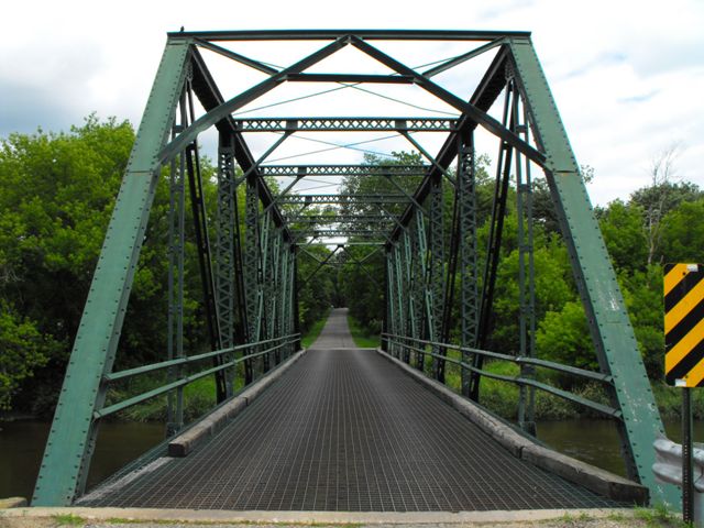
This 1910 bridge is an extremely unusual and early example of the truss bridge using bolted connections for all connection points. Its design is very similar to an average truss bridge from the period with riveted connection, except that there are bolts holding the members to the gusset plates.
During the late 1800s, pinned connections were the most common form of connection used on truss bridges because field riveting equipment and skilled labor was not available to erect the bridges on-site using riveted connections. Bolts were used sparingly, generally only to assemble segmented pieces of the larger shop riveted beams together, such as the top chord. As the 20th Century rolled around and field riveting became available, then riveted connections became common, and rivets were used for mostly everything until the 1960s. As such, bolted connections did not become overly popular until the 1970s.
This bridge is otherwise traditionally composed for a 1910 bridge, with built-up beams composing the truss web and an a-frame portal bracing. The bridge has been altered with the addition of welded plates to portions of the truss. In addition, some of the original bolts (having square-shaped nuts) have been replaced with modern high-strength bolts (having hexagonal bolts). These alterations have diminished the historic integrity of the bridge, however because of this bridge's bolted connections, the bridge remains significant.
![]()
![]()
![]()
This historic bridge has been relocated and is no longer at this location. See the main bridge page for a link to the new bridge location. This map is shown for reference purposes only.
Coordinates (Latitude, Longitude):
Search For Additional Bridge Listings:
Bridgehunter.com: View listed bridges within 0.5 miles (0.8 kilometers) of this bridge.
Bridgehunter.com: View listed bridges within 10 miles (16 kilometers) of this bridge.
Additional Maps:
Google Streetview (If Available)
GeoHack (Additional Links and Coordinates)
Apple Maps (Via DuckDuckGo Search)
Apple Maps (Apple devices only)
Android: Open Location In Your Map or GPS App
Flickr Gallery (Find Nearby Photos)
Wikimedia Commons (Find Nearby Photos)
Directions Via Sygic For Android
Directions Via Sygic For iOS and Android Dolphin Browser
USGS National Map (United States Only)
Historical USGS Topo Maps (United States Only)
Historic Aerials (United States Only)
CalTopo Maps (United States Only)

© Copyright 2003-2024, HistoricBridges.org. All Rights Reserved. Disclaimer: HistoricBridges.org is a volunteer group of private citizens. HistoricBridges.org is NOT a government agency, does not represent or work with any governmental agencies, nor is it in any way associated with any government agency or any non-profit organization. While we strive for accuracy in our factual content, HistoricBridges.org offers no guarantee of accuracy. Information is provided "as is" without warranty of any kind, either expressed or implied. Information could include technical inaccuracies or errors of omission. Opinions and commentary are the opinions of the respective HistoricBridges.org member who made them and do not necessarily represent the views of anyone else, including any outside photographers whose images may appear on the page in which the commentary appears. HistoricBridges.org does not bear any responsibility for any consequences resulting from the use of this or any other HistoricBridges.org information. Owners and users of bridges have the responsibility of correctly following all applicable laws, rules, and regulations, regardless of any HistoricBridges.org information.
![]()