

View Information About HSR Ratings
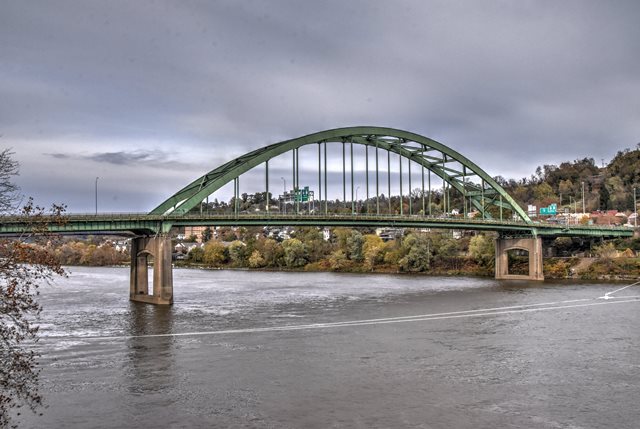
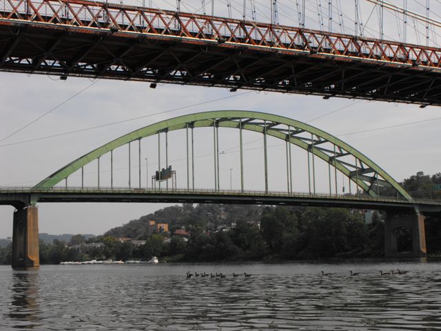
This bridge may not be the oldest steel arch bridge around, but it is a very large and nevertheless rare example of a historic steel arch bridge. It was built originally for US-40 and later became a part of I-70 when the Interstate Highway System was created. The bridge features riveted construction.
During construction of this bridge, falsework was placed in the river to hold the bridge up until the arch could be connected. Construction photos of the bridge are available here. The bridge cost $6,800,000 to construct.
A rather disappointing 2005 law excluded the Interstate Highway System and all associated bridges from Section 106 / Section 4(f) protections for historic bridges. The Fort Henry Bridge got lucky however. This bridge is is one of a select number of Interstate Highway Bridges considered to be nationally significant and it has been placed on a list of bridges that are still protected by Section 106 / Section 4(f) despite the exclusion law.
Erik D. Neely shared the following additional information about this bridge:
The Fort McHenry Bridge was originally constructed to carry US 250 over the Ohio River. As this bridge was being constructed, interstate 70 was being designed. The engineer's exploited the tunnels and bridge to facilitate construction of the interstate. US 40 was not rerouted over the Fort McHenry Bridge until the 70s. After the Wheeling Suspension Bridge was deemed outdated for modern vehicular traffic in the 1930's, a new steel suspension bridge was built a block upstream from the original suspension bridge. This bridge was then deemed unsafe after a traffic accident that sheared off some structural part of the bridge. This is when it was decided to merge US 40 onto the Fort McHenry bridge and demolish the damaged bridge due to repair costs.
Information and Findings From Federal Highway AdministrationDiscussion of Bridge Opened to traffic with fanfare in September 1955, the Fort Henry Bridge is a tied-arch design with a main span of 580 feet. Built at a cost of $6,800,000, the bridge represented a great leap forward for road transportation in the Wheeling area. It was part of a larger transportation plan for US 40 prepared by the engineering firm of Howard, Needles, Tammen, and Bergendoff. At the time of construction, the bridge was only the second tied arch over the Ohio River. Bridge Considered Historic By Survey: Yes, Section 106 and Section (4f) Must Be Conducted For Projects Involving This Bridge |
This bridge is tagged with the following special condition(s): Unorganized Photos
![]()
![]()
![]()
![]()
![]()
Coordinates (Latitude, Longitude):
Search For Additional Bridge Listings:
Bridgehunter.com: View listed bridges within 0.5 miles (0.8 kilometers) of this bridge.
Bridgehunter.com: View listed bridges within 10 miles (16 kilometers) of this bridge.
Additional Maps:
Google Streetview (If Available)
GeoHack (Additional Links and Coordinates)
Apple Maps (Via DuckDuckGo Search)
Apple Maps (Apple devices only)
Android: Open Location In Your Map or GPS App
Flickr Gallery (Find Nearby Photos)
Wikimedia Commons (Find Nearby Photos)
Directions Via Sygic For Android
Directions Via Sygic For iOS and Android Dolphin Browser
USGS National Map (United States Only)
Historical USGS Topo Maps (United States Only)
Historic Aerials (United States Only)
CalTopo Maps (United States Only)

© Copyright 2003-2024, HistoricBridges.org. All Rights Reserved. Disclaimer: HistoricBridges.org is a volunteer group of private citizens. HistoricBridges.org is NOT a government agency, does not represent or work with any governmental agencies, nor is it in any way associated with any government agency or any non-profit organization. While we strive for accuracy in our factual content, HistoricBridges.org offers no guarantee of accuracy. Information is provided "as is" without warranty of any kind, either expressed or implied. Information could include technical inaccuracies or errors of omission. Opinions and commentary are the opinions of the respective HistoricBridges.org member who made them and do not necessarily represent the views of anyone else, including any outside photographers whose images may appear on the page in which the commentary appears. HistoricBridges.org does not bear any responsibility for any consequences resulting from the use of this or any other HistoricBridges.org information. Owners and users of bridges have the responsibility of correctly following all applicable laws, rules, and regulations, regardless of any HistoricBridges.org information.
![]()