

View Information About HSR Ratings
This bridge is the oldest roadway bridge in the United States! As such, this is a bridge whose significance cannot be understated.
This bridge was built in the heart of the colonial era, about 16 years after William Penn had been granted the land for granted the land for the Pennsylvania Colony by King Charles II, and the idea of a United States was not even a thought at the time. The colonists who built this bridge could never have imagined that their bridge would endure for over 300 years, into the 21st Century, and carry motorized traffic... a traffic type that the colonists could not have imagined in their wildest dreams.
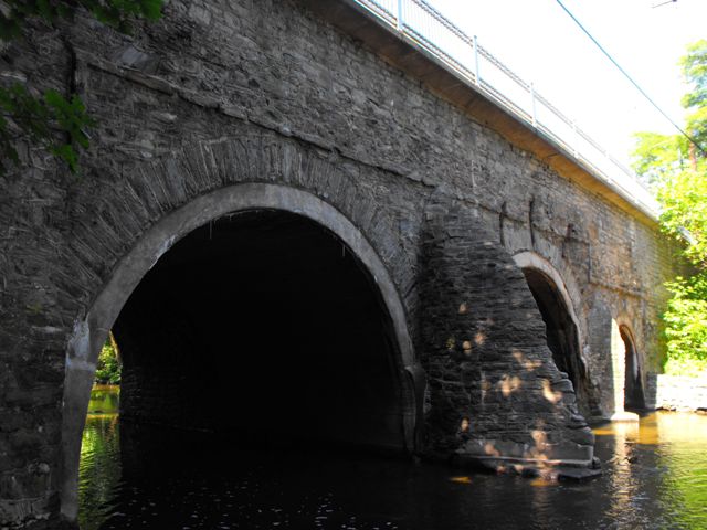
The bridge has been significantly altered over its period of history, as one might expect of a bridge built over 300 years ago in the colonial era that today continues to carry vehicular traffic at an impressive 20 ton weight limit. The most significant alteration was that the bridge was widened by adding a stone arch to the south side of the bridge in 1893. This 1893 arch follows the shape and design of the original 1697 structure and today this "new" part of the bridge is well over 100 years old and historic in its own right. The other major alteration is the 20th Century addition of a concrete ring to the inside of the 1697 arch. Other alterations include the deck replacements and the addition of a cantilevered sidewalk. Finally, the bridge's stonework has been repaired numerous times over its history, although most of these repairs have been carried out in-kind and were respective to the original materials and craftsmanship of the bridge. Despite all these alterations, the bridge continues to convey the design of the 1697 structure and on the 1697 half of the bridge continues to display a significant amount of original bridge material.
Even with the alterations present on the bridge, the shear age of this bridge and its association with the colonial history of the Americas (one of only a few surviving bridges with this distinction) make this bridge one of the most significant in the United States.
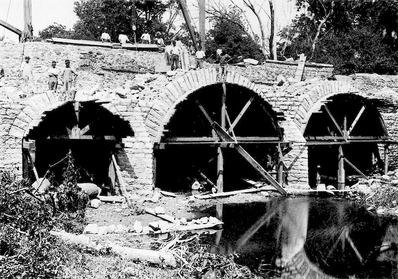
Above: Historical photo showing 1893 widening of bridge.
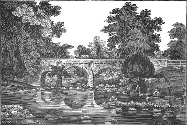
Above: ca. 1830 illustration of bridge by William Breton.
Information and Findings From Pennsylvania's Stone Arch Bridge Management PlanDiscussion of Bridge The oldest continuously used highway bridge in North America, the Frankford Avenue Bridge is an excellent candidate for long-term preservation. Built at the request of William Penn to connect his mansion with the nascent city of Philadelphia, the bridge remains a testament to a well-maintained stone arch bridge. More than three centuries after its construction, it carries an estimated 23,000 vehicles a day in an urban setting. It ranks in the upper third of all stone arch bridges under study in this plan. Its condition code is moderate, a result of scour at the abutments and piers. This bridge was posted for 20 tons on May 26, 1981. Its transportation code is very low, a result of high traffic volume and poor sight distance at one approach. Its waterway is adequate. However, because the bridge's historic fabric and form are largely intact, the cost to rehabilitate it would be relatively inexpensive. It stands in an urban area, where its traffic may increase in the future, with the potential to exacerbate an already low transportation code. The bridge is individually listed in the National Register of Historic Places and is part of Pennypack Park. The bridge enjoys extensive public support (five questionnaires, one letter, two emails, and one meeting at which the bridge was the primary focus). Recommendation: Recommended for long-term preservation. Ratings The Holmesburg, Frankford Avenue Bridge is owned by
PennDOT and is ranked 35th. Recommendation: Recommended for long-term preservation. |
![]()
![]()
![]()
Coordinates (Latitude, Longitude):
Search For Additional Bridge Listings:
Bridgehunter.com: View listed bridges within 0.5 miles (0.8 kilometers) of this bridge.
Bridgehunter.com: View listed bridges within 10 miles (16 kilometers) of this bridge.
Additional Maps:
Google Streetview (If Available)
GeoHack (Additional Links and Coordinates)
Apple Maps (Via DuckDuckGo Search)
Apple Maps (Apple devices only)
Android: Open Location In Your Map or GPS App
Flickr Gallery (Find Nearby Photos)
Wikimedia Commons (Find Nearby Photos)
Directions Via Sygic For Android
Directions Via Sygic For iOS and Android Dolphin Browser
USGS National Map (United States Only)
Historical USGS Topo Maps (United States Only)
Historic Aerials (United States Only)
CalTopo Maps (United States Only)

© Copyright 2003-2024, HistoricBridges.org. All Rights Reserved. Disclaimer: HistoricBridges.org is a volunteer group of private citizens. HistoricBridges.org is NOT a government agency, does not represent or work with any governmental agencies, nor is it in any way associated with any government agency or any non-profit organization. While we strive for accuracy in our factual content, HistoricBridges.org offers no guarantee of accuracy. Information is provided "as is" without warranty of any kind, either expressed or implied. Information could include technical inaccuracies or errors of omission. Opinions and commentary are the opinions of the respective HistoricBridges.org member who made them and do not necessarily represent the views of anyone else, including any outside photographers whose images may appear on the page in which the commentary appears. HistoricBridges.org does not bear any responsibility for any consequences resulting from the use of this or any other HistoricBridges.org information. Owners and users of bridges have the responsibility of correctly following all applicable laws, rules, and regulations, regardless of any HistoricBridges.org information.
![]()