
View Information About HSR Ratings
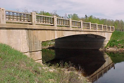
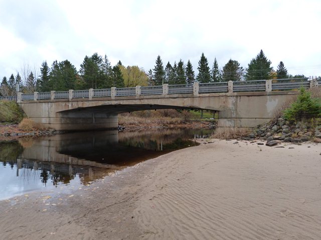
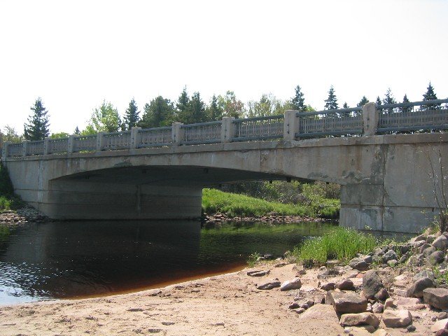
This bridge is a rare, unaltered example of a concrete rigid-frame bridge in Michigan. This type of bridge which integrates the abutment to the superstructure and often displays an arched superstructure like that seen here was common for overpasses on the earliest limited access highways in the United States. Otherwise, the bridge type does not seem to have gained popularity for water crossings in the United States. This is particularly true in Michigan where the type is rare. In contrast, the neighboring province of Ontario built an enormous number of concrete rigid frame bridges from the 1930s through the 1960s for both highway overpasses and water crossings. Because Ontario used a standard railing design that is very similar to Michigan's R4 railing (as seen on the Sand River Bridge), the Sand River Bridge looks very similar to rigid-frame bridges built for water crossings in Ontario.
Information and Findings From Michigan Historic Bridge InventoryNarrative Description This medium-span concrete bridge crosses the Sand River between the village of Sand River and the shore of Lake Superior. Carrying Highway M-28 (originally M-94), the gracefully proportioned structure is comprised of a single 56 foot span supported by - and rigidly tied to - concrete abutments on spread footings. The rigid frame span features a shallowly arched profile that springs from the abutments with a 4-foot thickness and crowns to an exceedingly thin, 1'-8'' section at mid-span. Architectural expression for the bridge is provided by the MSHD-standard concrete/steel guardrails and the Moderne horizontal scoring and radiused corners on the abutment sidewalls. The Sand River Bridge is in excellent condition, without major alteration. Designed by MSHD engineers early in 1939, the Sand River Bridge was, from the start, regarded as a noteworthy structure. "Unique design and a tidal wave combined to make this one of the most interesting bridge projects in Michigan during the past year," stated Michigan Roads and Construction. A contract to build the bridge was awarded on April 12 to the Alpine Excavating Company of St. Ignace. The contractors began work on the substructural excavation soon after, but on June 16 a six-foot-high surge of water from Lake Superior flooded the abutment cofferdams. The MSHD project engineer reported, "contractors' plant and cofferdams are completely inundated and it is a sorry looking site." The Alpine Excavating crew worked for two weeks to repair the damage, resuming construction in early July. The Sand River Bridge was completed later that year. It has carried vehicular traffic since, first as part of M-94 and later, after a route change, M-28. It functions in place now, with the replacement of the original cable guardrail`s at the approaches with Armco as the only alteration of note. The rigid frame configuration of the Sand River Bridge represented a recent trend in bridge design for MSHD. "The so-called rigid frame design, whose good appearance and economy have recommended it to the Department's engineers, was adopted for two bridge projects during the biennium," MSHD stated in 1940. "One is a concrete bridge carrying M-94 over Sand River northwest of Deerton. The other is a combined steel and concrete structure on US-2 over the Black River near Gilchrist. The highway department began using concrete rigid frame structures for bridges and grade separations in 1935. Developed by Westchester County, New York, in the early 1920s, the concrete rigid frame bridge became especially popular for federal relief projects during the 1930s. Both picturesque and practical, the flat or elliptically arched designs appealed to proponents of highway beautification. In Michigan State Highway Department never made widespread use of concrete rigid frame bridges for its rural highway crossings. "Owing to the general unreliable stability of the soil in this state," MSHD officials reported, "very few locations have previously been found where this type of bridge could be built." Most of these locations were at urban grade separations. This bridge in Alger County is the longest of the rural rigid frame spans in Michigan. Carrying a regionally important route, the Sand River Bridge is a Significant, well-preserved example of MSHD design experimentation of the 1930s.
|
![]()
![]()
![]()
![]()
Coordinates (Latitude, Longitude):
Search For Additional Bridge Listings:
Bridgehunter.com: View listed bridges within 0.5 miles (0.8 kilometers) of this bridge.
Bridgehunter.com: View listed bridges within 10 miles (16 kilometers) of this bridge.
Additional Maps:
Google Streetview (If Available)
GeoHack (Additional Links and Coordinates)
Apple Maps (Via DuckDuckGo Search)
Apple Maps (Apple devices only)
Android: Open Location In Your Map or GPS App
Flickr Gallery (Find Nearby Photos)
Wikimedia Commons (Find Nearby Photos)
Directions Via Sygic For Android
Directions Via Sygic For iOS and Android Dolphin Browser
USGS National Map (United States Only)
Historical USGS Topo Maps (United States Only)
Historic Aerials (United States Only)
CalTopo Maps (United States Only)

© Copyright 2003-2024, HistoricBridges.org. All Rights Reserved. Disclaimer: HistoricBridges.org is a volunteer group of private citizens. HistoricBridges.org is NOT a government agency, does not represent or work with any governmental agencies, nor is it in any way associated with any government agency or any non-profit organization. While we strive for accuracy in our factual content, HistoricBridges.org offers no guarantee of accuracy. Information is provided "as is" without warranty of any kind, either expressed or implied. Information could include technical inaccuracies or errors of omission. Opinions and commentary are the opinions of the respective HistoricBridges.org member who made them and do not necessarily represent the views of anyone else, including any outside photographers whose images may appear on the page in which the commentary appears. HistoricBridges.org does not bear any responsibility for any consequences resulting from the use of this or any other HistoricBridges.org information. Owners and users of bridges have the responsibility of correctly following all applicable laws, rules, and regulations, regardless of any HistoricBridges.org information.
![]()