

View Information About HSR Ratings

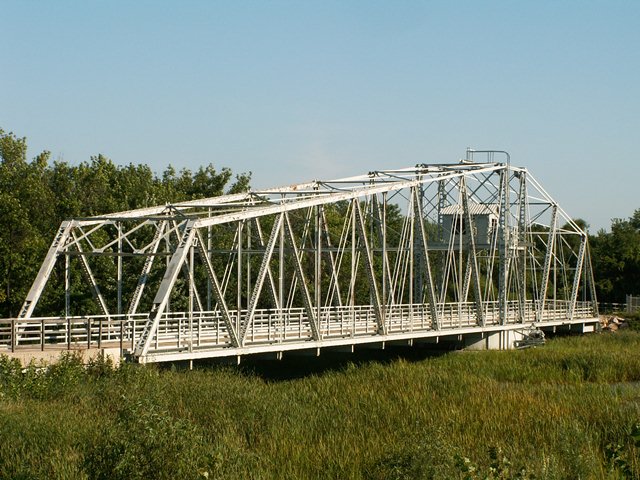
This magnificent climax to the Centennial Trail system that has been created in the area is a structure that was once common in the area 100 years ago but is today distinguished as the last highway swing bridge remaining from the Sanitary and Ship Canal. A few railroad swing bridges do remain however. This bridge is unusual as swing bridges go not only for its length, but also for its bobtail (asymmetrical) design. This bridge was closed to traffic in 1990, and eventually replaced by a modern bridge. View the archived National Bridge Inventory file for information about this bridge in its previous location. This historic bridge was relocated here to this nearby location in 1996. In addition to its significance as a rare surviving highway bridge, the bridge is also significant for its Warren truss configuration, which is rare among pin-connected truss bridges. This bridge is visually beautiful, and it owes much of this beauty to the extensive network of lattice and v-lacing on its built-up members, chords, and portal bracing designs. There is a lot to look at on this bridge! It is a must-see attraction of any Chicagoland visit.
A report by the canal's chief engineer, Isham Randolph provided information about the bridge as originally constructed. Heldmaier and Neu were the substructure contractors, with C. L. Strobel the superstructure contractor. Original roadway was 20 feet. Total weight of iron and steel in the bridge was 339,505 pounds, with a 208,100 pound counterweight.
This bridge is tagged with the following special condition(s): Reused
![]()
![]()
![]()
Coordinates (Latitude, Longitude):
Search For Additional Bridge Listings:
Bridgehunter.com: View listed bridges within 0.5 miles (0.8 kilometers) of this bridge.
Bridgehunter.com: View listed bridges within 10 miles (16 kilometers) of this bridge.
Additional Maps:
Google Streetview (If Available)
GeoHack (Additional Links and Coordinates)
Apple Maps (Via DuckDuckGo Search)
Apple Maps (Apple devices only)
Android: Open Location In Your Map or GPS App
Flickr Gallery (Find Nearby Photos)
Wikimedia Commons (Find Nearby Photos)
Directions Via Sygic For Android
Directions Via Sygic For iOS and Android Dolphin Browser
USGS National Map (United States Only)
Historical USGS Topo Maps (United States Only)
Historic Aerials (United States Only)
CalTopo Maps (United States Only)

© Copyright 2003-2024, HistoricBridges.org. All Rights Reserved. Disclaimer: HistoricBridges.org is a volunteer group of private citizens. HistoricBridges.org is NOT a government agency, does not represent or work with any governmental agencies, nor is it in any way associated with any government agency or any non-profit organization. While we strive for accuracy in our factual content, HistoricBridges.org offers no guarantee of accuracy. Information is provided "as is" without warranty of any kind, either expressed or implied. Information could include technical inaccuracies or errors of omission. Opinions and commentary are the opinions of the respective HistoricBridges.org member who made them and do not necessarily represent the views of anyone else, including any outside photographers whose images may appear on the page in which the commentary appears. HistoricBridges.org does not bear any responsibility for any consequences resulting from the use of this or any other HistoricBridges.org information. Owners and users of bridges have the responsibility of correctly following all applicable laws, rules, and regulations, regardless of any HistoricBridges.org information.
![]()