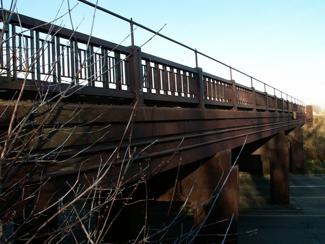
This unusual design of railroad overpass is unlike other
railroad overpasses found in Flint and along the CN line in the area. MDOT
provides a detailed history of the bridges. It used to have a highway overpass
to go with it, but this bridge, which served 14th Street, was demolished by the time HistoricBridges.org visited the bridge although the abutments and pedestrian stairway that
was associated with it still remains. 14th Street and its Saginaw Street
overpass was rendered useless when the nearby expressway was completed, which
cut the road off. The rail bridge remains however, and continues to serve rail
traffic. This railroad bridge is significant as a World War II project that was
built as Michigan worked to improve efficiency of production during war time.
These unusual wartime circumstances, which caused a steel shortage within the
country for domestic projects, may explain the use of concrete rather than steel
for the superstructure, which for a railroad overpass is less common. The MDOT history below appears to be in error in one area that should be noted. It claims that the railroad bridge was abandoned and that 14th Street was switched over to
use the railroad bridge. There is no evidence that this was the case. The railroad bridge has two active tracks on it, and the bridge that has been demolished lines up with 14th Street on the map.
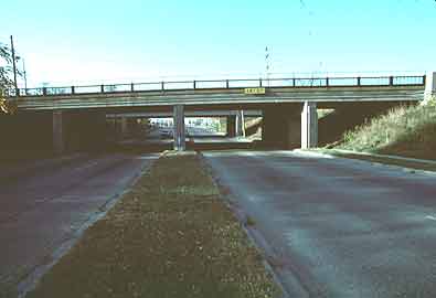
The Saginaw
Street Underpasses are a pair of identical structures - one now open,
one closed - that carry Fourteenth Street and an abandoned line of the
Grand Trunk Western Railroad over Saginaw Street (M-54 BR) in central
Flint. Each overpass has four concrete spans, the longest of which
extends 38 feet.
The original highway overpass (now closed) is configured as a T-beam
structure, with relatively shallow girders braced by solid concrete
diaphragms. The railroad structure (now carrying Fourteenth Street) "is
of unique design," as described by MSHD, "consisting of a heavily
reinforced concrete slab which supports the railroad tracks on ruber
pads without the use of ties or ballast." Both structures are supported
by concrete abutments and spill-through piers. The abutments and piers
provide much of the bridges architectural expression, with their Art
Moderne concrete corbeling and scored vertical lines. The asphalt-paved
concrete roadways on both are flanked by concrete sidewalks, which are
in turn bounded by MSHD standard, ornamental steel guardrails with
paneled concrete posts. The guardrail extends continuously between the
two overpasses to join them on both sides of the highway. It is used on
the concrete stairs between the two structures that extend down the
hillsides from the Fourteenth street level to Saginaw Street. In
excellent physical condition, both parts of the Saginaw Street Underpass
are unaltered other than the removal of railroad rails from the slab
structure.
The Saginaw Street Underpasses were designed in 1941 by the Michigan
State Highway Department as part of war-related reconstruction of
Saginaw Street through Flint. For this crossing, the highway department
delineated two structures that appeared almost identical but in reality
used entirely different superstructural systems. The original Fourteenth
Street span employed an MSHD-standard T-beam superstructure; the Grand
Trunk Western Railroad span used a massive concrete slab, with rubber
dampeners to isolate train vibration from the substructure. "This design
was especially chosen for this location," MSHD explained in its
Nineteenth Biennial Report, "because its shallow depth permitted the
separation of grades without the necessity of raising the tracks to an
excessive height or of depressing the streetway to a point where pumping
would be required to drain the under-pass area." The highway department
pushed construction of the highway and its related structures through
1941, finishing them before July 1942. After their opening, MSHD stated:
"Completion of this project was particularly important since it removed
a serious hazard which existed at the old railroad intersection and, in
addition, relieved a condition of extreme traffic congestion.
This state highway urban-business route now has divided roadways
throughout the length of the project." The new route would provide
improved access to the Fisher Body Plant, then engaged in wartime
production. Built as an integral part of one of the state's most
important WWII urban projects outside of the Detroit are, the Saginaw
Street Underpasses are historically significant for their role in this
pivotal period of Michigan transportation history.
Photo Galleries and Videos: Saginaw Street Railroad Overpass
Original / Full Size Photos A collection of overview and detail photos. This gallery offers photos in the highest available resolution and file size in a touch-friendly popup viewer. Alternatively, Browse Without Using Viewer
Mobile Optimized Photos A collection of overview and detail photos. This gallery features data-friendly, fast-loading photos in a touch-friendly popup viewer. Alternatively, Browse Without Using Viewer