

View Information About HSR Ratings
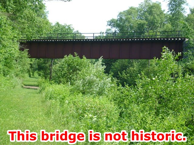
This bridge is a welded deck plate girder bridge. It sits on abutments that are a combination of concrete and stone. Due to its welded, non-riveted construction, the plate girder appears to be fairly new, likely dating to after 1970. The concrete and stone in the abutments, both which appear to predate the current plate girder, suggest that at least two bridges preceded the existing plate girder, one bridge dating to the concrete portion of the abutments, and an earlier one that would have been built on stone abutments.
Marc Scotti provided the following details about the Black River Canal, which is a historic canal that is today abandoned.
The Black River Canal goes under the railroad bridge in question. It ran north off the Erie main line, to Boonville, Lyons Falls and then into the river itself to Carthage. There were a handful of these "laterals"
across the state, and a couple remain in use today. Although it seems to make no sense to me at all, I could never find any evidence that the rapids and falls in the lower Black River were ever by-passed so boats could actually go all the
way into Lake Ontario. So instead of connecting to the Seaway, it appears to have been a hundred-mile dead end.
This canal was the last of the "towpath" canals to survive in active use into the Barge Canal era. According to the
Images Of America book, it's busiest years were in the 19-teens, when a lot of materials for the new canals were transported down it. Unfortunately, those cargoes during the busy years made the canal obsolete immediately. Once the new
canals were open, it's tiny dimensions were no match for the new locks, which were about 6 times the size. And horse drawn boats weren't exactly the fastest way to travel by that time either. So this canal was a goner maybe 10 years after
the new ones opened. But it still lasted many years longer than all of the others that weren't enlarged again. It's unfortunate that this canal is largely forgotten, because the engineering for many of the lock combines and the changes in
elevation blew away the Erie, which of course got all the attention.
Another factor is that the vast forests of the Adirondacks were logged out of existence by early 1900's, so one of the canal's main traffic sources dried right up.
The railroads drove plenty more nails into the coffin, but their prosperity didn't last a whole lot longer. The parallel St. Lawrence Division was severed as a through route around '62. The northern half seemed to be busier to me, but
that's now out of service and up for abandonment. I have no idea how the southern half still survives, because it was down to just 3 active customers when I lived by it until '94, and the paper mill closed shortly after that. They survive
on a trickle of traffic maybe 2 days a week, somehow.
So it's another example of the boom and bust cycles of American industry. Although navigation ended in the early '20's, the canal still does serve as a very important feeder of
water to the summit of the present-day active canals at Rome.
The museum just opened a few years ago, but I have no idea how much they can reasonably expect to accomplish. They built a big authentic wooden barge, but it sits on
land, and doesn't travel through the canal.
An Alco Century-425 locomotive has been identified as one of the train engines that cross this bridge. This particular engine started on the Erie-Lackawanna, which means it was made in Schenectady, New York. The color scheme on it is from it's time on the British Columbia Railway. Alco engines have not been made since the 1960s, but a number still remain in use as of 2013.
There is often some confusion as to what makes a bridge (or other structure) historic. This bridge has very old abutments. Although altered, even the concrete alterations to the abutments are very old. The canal is a historic canal and an important reminder of how this country's transportation systems developed and evolved. One could even say that historic train engines at least sometimes cross the bridge. Some would say that this bridge is therefore historic because it is part of all these things. However, this is not the case. The abutments are the only part of the bridge that appear to be old, and they alone do not present any unusual or noteworthy engineering or heritage significance. The welded plate girder appears to either date to after 1970 or even if it was older is regardless an example of modern bridge design that is still used by railroads in new bridge construction today. Sometimes, when a canal or railroad line itself is historic, bridges along the railroad line or canal are considered historic because they "contribute" to the historic significance of the canal or the railroad line. However, this bridge, with a superstructure that clearly dates to after the canal's "period of significance" could not be considered to contribute to the heritage of the canal. If the stone abutments dated to the use of the canal, the abutments might be able to be considered contributing, however the plate girder superstructure itself cannot.
![]()
![]()
![]()
Coordinates (Latitude, Longitude):
Search For Additional Bridge Listings:
Bridgehunter.com: View listed bridges within 0.5 miles (0.8 kilometers) of this bridge.
Bridgehunter.com: View listed bridges within 10 miles (16 kilometers) of this bridge.
Additional Maps:
Google Streetview (If Available)
GeoHack (Additional Links and Coordinates)
Apple Maps (Via DuckDuckGo Search)
Apple Maps (Apple devices only)
Android: Open Location In Your Map or GPS App
Flickr Gallery (Find Nearby Photos)
Wikimedia Commons (Find Nearby Photos)
Directions Via Sygic For Android
Directions Via Sygic For iOS and Android Dolphin Browser
USGS National Map (United States Only)
Historical USGS Topo Maps (United States Only)
Historic Aerials (United States Only)
CalTopo Maps (United States Only)

© Copyright 2003-2024, HistoricBridges.org. All Rights Reserved. Disclaimer: HistoricBridges.org is a volunteer group of private citizens. HistoricBridges.org is NOT a government agency, does not represent or work with any governmental agencies, nor is it in any way associated with any government agency or any non-profit organization. While we strive for accuracy in our factual content, HistoricBridges.org offers no guarantee of accuracy. Information is provided "as is" without warranty of any kind, either expressed or implied. Information could include technical inaccuracies or errors of omission. Opinions and commentary are the opinions of the respective HistoricBridges.org member who made them and do not necessarily represent the views of anyone else, including any outside photographers whose images may appear on the page in which the commentary appears. HistoricBridges.org does not bear any responsibility for any consequences resulting from the use of this or any other HistoricBridges.org information. Owners and users of bridges have the responsibility of correctly following all applicable laws, rules, and regulations, regardless of any HistoricBridges.org information.
![]()