

View Information About HSR Ratings
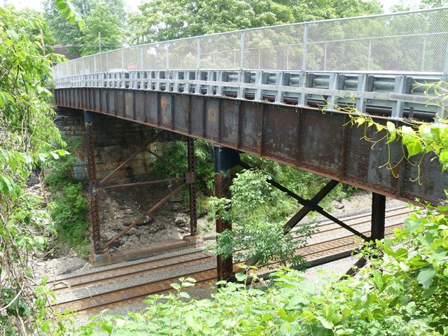
This bridge is a plate girder bridge. All but the ends of the original pipe railings have been removed. Builder plaques remain on the remaining ends of the original railings. The top of the bridge is today unsightly, with cyclone fencing, no original railings, and modern Armco guardrail. Beside the bridge however, the girders and supports including built-up steel bents and stone abutments are largely unaltered and represent the bridge type well. The bridge is noteworthy because of its continuous design as opposed to using simple spans. It also contributes to the historic Pennsylvania Railroad mainline, which the bridge crosses.
Information and Findings From Pennsylvania's Historic Bridge InventoryDiscussion of Bridge The 3 span, 145' long and 26' wide, built up deck girder bridge has a 61' long span over the railroad tracks and 38' long approach spans. The substructure consists of ashlar abutments and built up steel column bents. The floorbeams are built up, and the stringers and deck are wood. The original 4 rail high metal pipe railing remains on the west side. It has been replaced with beam guiderail railings between the road and the sidewalk and a chain link fence on the sidewalk's other side. The builder's plaque is in the original railing end post. Although an example of a common bridge type, the bridge is historically and technologically significant for its association with the Pennsylvania RR main line. Discussion of Surrounding Area The bridge carries a 2 lane street over 2 active railroad tracks and an access road. The line, now a Conrail line, is the former main line of the Pennsylvania Railroad that PHMC has determined eligible. The surrounding area of North Irwin is a mix of early 20th century houses and modern structures, both residential and commercial. The area does not have the consistency or cohesiveness to be a historic district. Bridge Considered Historic By Survey: Yes |
![]()
![]()
![]()
Coordinates (Latitude, Longitude):
Search For Additional Bridge Listings:
Bridgehunter.com: View listed bridges within 0.5 miles (0.8 kilometers) of this bridge.
Bridgehunter.com: View listed bridges within 10 miles (16 kilometers) of this bridge.
Additional Maps:
Google Streetview (If Available)
GeoHack (Additional Links and Coordinates)
Apple Maps (Via DuckDuckGo Search)
Apple Maps (Apple devices only)
Android: Open Location In Your Map or GPS App
Flickr Gallery (Find Nearby Photos)
Wikimedia Commons (Find Nearby Photos)
Directions Via Sygic For Android
Directions Via Sygic For iOS and Android Dolphin Browser
USGS National Map (United States Only)
Historical USGS Topo Maps (United States Only)
Historic Aerials (United States Only)
CalTopo Maps (United States Only)

© Copyright 2003-2024, HistoricBridges.org. All Rights Reserved. Disclaimer: HistoricBridges.org is a volunteer group of private citizens. HistoricBridges.org is NOT a government agency, does not represent or work with any governmental agencies, nor is it in any way associated with any government agency or any non-profit organization. While we strive for accuracy in our factual content, HistoricBridges.org offers no guarantee of accuracy. Information is provided "as is" without warranty of any kind, either expressed or implied. Information could include technical inaccuracies or errors of omission. Opinions and commentary are the opinions of the respective HistoricBridges.org member who made them and do not necessarily represent the views of anyone else, including any outside photographers whose images may appear on the page in which the commentary appears. HistoricBridges.org does not bear any responsibility for any consequences resulting from the use of this or any other HistoricBridges.org information. Owners and users of bridges have the responsibility of correctly following all applicable laws, rules, and regulations, regardless of any HistoricBridges.org information.
![]()