

View Information About HSR Ratings
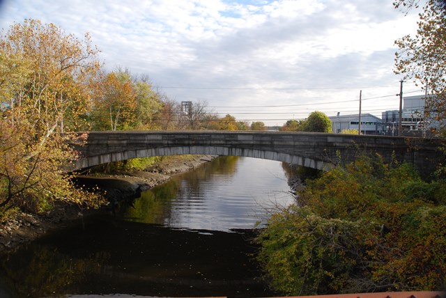
This slender concrete arch bridge features a decorative stone facing. It is today closed to vehicular traffic.
Information and Findings From Pennsylvania's Historic Bridge InventoryDiscussion of Bridge The one-span, 140'-long, reinforced concrete deck arch bridge built in 1930 with stone parapets is supported on concrete abutments. The spandrels are finished with an ashlar veneer with voussoirs to give the appearance of a stone arch bridge. The county-built bridge is an undistinguished example of its type and design with no distinctive or uncommon details. Reinforced concrete arch bridges have been in use in the local context since at least the first decade of the 20th century. Decorative stone veneers are not unusual, and can be found on earlier arch bridges in the county. The ashlar pattern is characteristic of bridges built in the early 1930s by Delaware County Engineer George Wright. Other bridges of more handsome proportions and technological distinction represent the detailing in the local context (e.g. 23 3029 0030 3266). Discussion of Surrounding Area The bridge carries a 2 lane street and 2 sidewalks over a stream on the east side of Chester. The bridge is currently closed to traffic by a chain link fence and gate. It is used to provide access to a contractor's yard with late-20th-century service buildings at the east end of the bridge. The bridge is located north of the Penn Shipbuilding Company, but is divided from the shipyard by a wooded tract. The industrial setting is dominated by late-20th-century buildings, and it does not have historic district potential. Bridge Considered Historic By Survey: No |
![]()
![]()
![]()
Coordinates (Latitude, Longitude):
Search For Additional Bridge Listings:
Bridgehunter.com: View listed bridges within 0.5 miles (0.8 kilometers) of this bridge.
Bridgehunter.com: View listed bridges within 10 miles (16 kilometers) of this bridge.
Additional Maps:
Google Streetview (If Available)
GeoHack (Additional Links and Coordinates)
Apple Maps (Via DuckDuckGo Search)
Apple Maps (Apple devices only)
Android: Open Location In Your Map or GPS App
Flickr Gallery (Find Nearby Photos)
Wikimedia Commons (Find Nearby Photos)
Directions Via Sygic For Android
Directions Via Sygic For iOS and Android Dolphin Browser
USGS National Map (United States Only)
Historical USGS Topo Maps (United States Only)
Historic Aerials (United States Only)
CalTopo Maps (United States Only)

© Copyright 2003-2024, HistoricBridges.org. All Rights Reserved. Disclaimer: HistoricBridges.org is a volunteer group of private citizens. HistoricBridges.org is NOT a government agency, does not represent or work with any governmental agencies, nor is it in any way associated with any government agency or any non-profit organization. While we strive for accuracy in our factual content, HistoricBridges.org offers no guarantee of accuracy. Information is provided "as is" without warranty of any kind, either expressed or implied. Information could include technical inaccuracies or errors of omission. Opinions and commentary are the opinions of the respective HistoricBridges.org member who made them and do not necessarily represent the views of anyone else, including any outside photographers whose images may appear on the page in which the commentary appears. HistoricBridges.org does not bear any responsibility for any consequences resulting from the use of this or any other HistoricBridges.org information. Owners and users of bridges have the responsibility of correctly following all applicable laws, rules, and regulations, regardless of any HistoricBridges.org information.
![]()