

View Information About HSR Ratings
Additional Information: This bridge was an AISC Medium Span Prize Bridge.

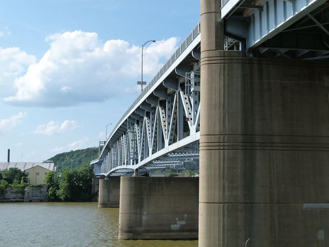
While this is a late example of a riveted cantilever truss bridge, and may tend to be overshadowed by Pittsburgh's immense collection of historic bridges, this bridge nevertheless exhibits some interesting and unusual details. The main spans of this bridge are a cantilever deck truss system. The system consists of 225 foot anchor arm spans, and a 400 foot central span consisting of 100 foot cantilever arms and a 200 foot suspended span. The overall form of this truss is unusual for a deck truss. The top chord is not horizontal and instead overall follows a 3.5% profile grade, giving the top a slight arched appearance. The center truss span has a polygonal (arch-like) bottom chord, which is not uncommon for a cantilever (or continuous) deck truss, but what is unusual is that the "arch" shape is very shallow.
The approach span system of this bridge at the northern end is also of interest. It consists of deck plate girder spans configured as two parallel superstructures sharing a common deck/roadway and pier system. These girder spans are also configured as cantilever spans that include suspended spans.
![]()
![]()
![]()
Coordinates (Latitude, Longitude):
Search For Additional Bridge Listings:
Bridgehunter.com: View listed bridges within 0.5 miles (0.8 kilometers) of this bridge.
Bridgehunter.com: View listed bridges within 10 miles (16 kilometers) of this bridge.
Additional Maps:
Google Streetview (If Available)
GeoHack (Additional Links and Coordinates)
Apple Maps (Via DuckDuckGo Search)
Apple Maps (Apple devices only)
Android: Open Location In Your Map or GPS App
Flickr Gallery (Find Nearby Photos)
Wikimedia Commons (Find Nearby Photos)
Directions Via Sygic For Android
Directions Via Sygic For iOS and Android Dolphin Browser
USGS National Map (United States Only)
Historical USGS Topo Maps (United States Only)
Historic Aerials (United States Only)
CalTopo Maps (United States Only)

© Copyright 2003-2024, HistoricBridges.org. All Rights Reserved. Disclaimer: HistoricBridges.org is a volunteer group of private citizens. HistoricBridges.org is NOT a government agency, does not represent or work with any governmental agencies, nor is it in any way associated with any government agency or any non-profit organization. While we strive for accuracy in our factual content, HistoricBridges.org offers no guarantee of accuracy. Information is provided "as is" without warranty of any kind, either expressed or implied. Information could include technical inaccuracies or errors of omission. Opinions and commentary are the opinions of the respective HistoricBridges.org member who made them and do not necessarily represent the views of anyone else, including any outside photographers whose images may appear on the page in which the commentary appears. HistoricBridges.org does not bear any responsibility for any consequences resulting from the use of this or any other HistoricBridges.org information. Owners and users of bridges have the responsibility of correctly following all applicable laws, rules, and regulations, regardless of any HistoricBridges.org information.
![]()