HistoricBridges.org Menu: HistoricBridges.org Menu:


We Recommend:
Bach Steel - Experts at historic truss bridge restoration.

HistoricBridges.org: Bridge Browser

133rd Avenue Bridge

133rd Avenue Bridge

Primary Photographer(s): Nathan Holth

Bridge Documented: November 20, 2005 - April 16, 2014

View Photos
and Videos
View Maps
and Links

Facility Carried / Feature Intersected
Bridge Park Trail Over Dickinson Creek
Location
Rural: Calhoun County, Michigan: United States
Construction Date and Builder / Engineer
1897 By Builder/Contractor: Michigan Bridge Company of Portland, Michigan
Rehabilitation Date
1999
Main Span Length
64.0 Feet (19.5 Meters)
Structure Length
66.0 Feet (20.1 Meters)
Roadway Width
14 Feet (4.27 Meters)
Spans
1 Main Span(s)
Inventory Number
03310H00009B010

Historic Significance Rating (HSR)
View Information About HSR Ratings

Bridge Documentation

View Archived National Bridge Inventory Report - Has Additional Details and Evaluation

View Historic American Engineering Record (HAER) Documentation For This Bridge

HAER Data Pages, PDF

This bridge has been moved and restored, and now resides in Historic Bridge Park.

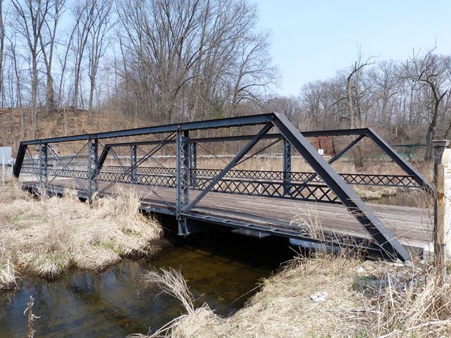
This bridge was the first bridge to be placed in Calhoun County's Historic Bridge Park. It is a half-hip Pratt pony truss. It is composed of four panels making up a 64 foot bridge. The width of the deck is 14 feet. The bridge was built in 1897 by the Michigan Bridge Company. It features pinned connections, and has v-lacing on the verticals and under the top chord. There are a number of remaining half-hip pony truss bridges left in Michigan, although few are preserved, and most are abandoned. The preservation of this bridge is important because it is a representative example of a once-common type of bridge that is quickly disappearing.

Information and Findings From Michigan Historic Bridge Inventory

Narrative Description

The following description credited to Elaine Davis.

MDOT Historic Bridge 133rd. Ave. / Rabbit River

Formerly spanning the Rabbit River in Hopkins Township, Allegan County,Michigan, the bridge is known today as the 133rd Avenue Bridge. It was built in 1897 by the Michigan Bridge Company of Portland, Michigan,owned by Samuel S. Ramsey and his son, Claude. In 1993, the bridge was considered unable to support vehicular traffic and was closed while the county scheduled the bridge for replacement.

It is a small bridge - only 64 feet long - and for a span of 96 years,it carried farm residents over the river on its single span.  The road was laid out between the times of publication of two plat maps, 1873 and 1895, to carry farm traffic to and from connecting roads to the rural schools and churches, to markets in nearby small towns such as Hopkins and Hilliards and to the L.S.M.S. railroad depot at Hopkins Station.

The Rabbit River is shallow where 133rd Avenue crosses, and perhaps in the early years travelers forded the river. As the demand for good roads year around increased, and as heavy steam traction equipment came into use for harvesting, the need for a strong bridge grew.  High water in January 1897 washed out the small bridge there. In late April, 1897, the Hopkins Township board let the contract for the iron bridge to the Michigan Bridge Co. for $715.

The technical description for the 133rd Ave. Bridge is a four-panel half-hip pin-connected Pratt steel truss, 64feet long, with a 14 foot roadway. It was removed from Allegan County in 1998 to the Calhoun County Road Commission shop where it was repaired, cleaned and repainted. Then it was re-erected in the Calhoun County Historic Bridge Park in 1999, to serve as a pedestrian bridge, and it has the honor of being the first bridge placed in the park.   It is expected to be good for another hundred years!


This bridge is tagged with the following special condition(s): Reused

Divider

Photo Galleries and Videos: 133rd Avenue Bridge


View Photo Gallery

2005 Bridge Photo-Documentation

A collection of overview and detail photos. This photo gallery contains a combination of Original Size photos and Mobile Optimized photos in a touch-friendly popup viewer.
Alternatively, Browse Without Using Viewer

Divider

View Photo Gallery

2014 Bridge Photo-Documentation

Original / Full Size Photos
A collection of overview and detail photos. This gallery offers photos in the highest available resolution and file size in a touch-friendly popup viewer.
Alternatively, Browse Without Using Viewer

Divider

View Photo Gallery

2014 Bridge Photo-Documentation

Mobile Optimized Photos
A collection of overview and detail photos. This gallery features data-friendly, fast-loading photos in a touch-friendly popup viewer.
Alternatively, Browse Without Using Viewer

Divider

Maps and Links: 133rd Avenue Bridge

The above map shows the current location of the bridge. The bridge originally crossed the Rabbit River on 133rd Avenue, Allegan County, Michigan

Coordinates (Latitude, Longitude):

Search For Additional Bridge Listings:

Bridgehunter.com: View listed bridges within 0.5 miles (0.8 kilometers) of this bridge.

Bridgehunter.com: View listed bridges within 10 miles (16 kilometers) of this bridge.

HistoricBridges.org Bridge Browser: View listed bridges within 0.5 miles (0.8 kilometers) of this bridge.

HistoricBridges.org Bridge Browser: View listed bridges within 10 miles (16 kilometers) of this bridge.

2021 National Bridge Inventory: View listed bridges within 0.5 miles (0.8 kilometers) of this bridge.

Additional Maps:

Google Maps

Google Streetview (If Available)

Bing Maps

OpenStreetMap

GeoHack (Additional Links and Coordinates)

Apple Maps (Via DuckDuckGo Search)

Apple Maps (Apple devices only)

MapQuest

HERE We Go Maps

ACME Mapper

Waze Map

Android: Open Location In Your Map or GPS App

Flickr Gallery (Find Nearby Photos)

Wikimedia Commons (Find Nearby Photos)

Directions Via Sygic For Android

Directions Via Sygic For iOS and Android Dolphin Browser

USGS National Map (United States Only)

Historical USGS Topo Maps (United States Only)

Historic Aerials (United States Only)

CalTopo Maps (United States Only)


Divider
 
Home Top

Divider

About - Contact

© Copyright 2003-2024, HistoricBridges.org. All Rights Reserved. Disclaimer: HistoricBridges.org is a volunteer group of private citizens. HistoricBridges.org is NOT a government agency, does not represent or work with any governmental agencies, nor is it in any way associated with any government agency or any non-profit organization. While we strive for accuracy in our factual content, HistoricBridges.org offers no guarantee of accuracy. Information is provided "as is" without warranty of any kind, either expressed or implied. Information could include technical inaccuracies or errors of omission. Opinions and commentary are the opinions of the respective HistoricBridges.org member who made them and do not necessarily represent the views of anyone else, including any outside photographers whose images may appear on the page in which the commentary appears. HistoricBridges.org does not bear any responsibility for any consequences resulting from the use of this or any other HistoricBridges.org information. Owners and users of bridges have the responsibility of correctly following all applicable laws, rules, and regulations, regardless of any HistoricBridges.org information.

Admin Login

Divider