

View Information About HSR Ratings

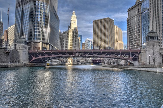
In 1930 this bridge received the "Most Beautiful Steel Bridge" award from the American Institute of Steel Construction. At the time this bridge was built, it was one of the first to use Chicago's unique design which raised the position of the deck truss up just far enough so that the top chord is above the deck like a pony truss, where it can act as a guardrail and also increase the clearance under the bridge and the streamlined appearance of the bridge. This design of truss is described at the railing height truss.
Today, there are a number of bridges in Chicago that display the railing height truss design, and they are all attractive structures, however the older examples like this one display more ornate bridge tender houses. There are three railing height trusses, including Wabash Avenue Bridge, that are located one right after another on this section of the river. Of those three, this is the oldest.

This bridge is the first at this location. It connected Wabash Avenue to what was then called Cass Street to the north. Today, Cass Street is also called Wabash Avenue. The bridge was intended to provide a crossing where once was long missing yet badly needed. It also helped relieve traffic on busy Michigan Avenue to the east.
A memorial plaque on the bridge shows that the nickname "Irv Kupcinet Bridge" was appended to this bridge in 1985 to honor a well-known Sun Times Columnist often called simply "Cup" who produced "Cup's Column" for over 60 years. At one time, the Chicago Sun Times building was located near this bridge, where Trump Tower is today. This explains why the bridge was named after a columnist rather than another such as Kinzie Street, which is near the current Sun Times Building.

James Simpson was Chairman of the Chicago Plan Commission when this bridge was built. Click on his photo shown to the right to view an enlarged image that includes a short biography.
For many years, this bridge displayed sidewalk railings that were not original to the bridge, and were very plain and unsightly in appearance. Today, those railings have been removed and replaced with attractive railings that replicate the appearance of the original railings that were on the bridge. These railings greatly improve the visual beauty of the bridge. Chicago is one of the few places in the United States that has actually brought back replicas of original railings on bridges that have lost original railings.
The Annual Report of the Public Works Department in 1930 provided some details. The bridge had 9,500 cubic yards of concrete with 900,000 pounds of reinforcing steel. The bridge's machinery in total weighed 320 tons. Each leaf of the bridge was mounted on two trunnions with a 30 inch diameter. Each trunnion carried about 1,400 tons. Each bridge leaf was equipped with two 100 H.P. electric motors. The bridge tender houses were built with a steel framing, reinforced concrete floors and stairs, and with Indiana limestone walls finished inside with brick. The building was topped off with a copper lead clad roof and associated ornamentation. The bridge was opened to traffic December 20, 1930. The report also states the roles of the various contractors for the work, something the bridge plaque omits. Ketler-Elliott Company constructed both the superstructure and substructure including the viaduct system that leads up to the north end of the bridge. Street adjustments and the northern approach was constructed by William J. Newman Company. Electrical equipment was installed by Pierce Electric Company. The bridge tender houses were built by George P. Cullen, Inc. Plumbing was installed by W. W. Watson.


|
Main Plaque WABASH AVENUE BRIDGECITY OF CHICAGO 1930 WM HALE THOMPSON MAYOR RICHARD W. WOLFE COMMISSIONER OF PUBLIC WORKS EDWARD F. MOORE DEPUTY COMM. OF PUBLIC WORKS
CHICAGO PLAN COMMISSION
CONTRACTORS
GEO. P. CULLEN INC. |
|
AISC Plaque AMERICAN INSTITUTE OF STEEL CONSTRUCTIONANNUAL AWARD OF MERIT MOST BEAUTIFUL STEEL BRIDGE
|
Rehabilitation Plaque This bridge is namedTHE IRV KUPCINET BRIDGE IN HONOR OF "KUP" THE CHICAGO SUN-TIMES COLUMNIST Unanimously approved by the Chicago City Council December 23, 1985 HAROLD WASHINGTON, Mayor PAUL A. KARAS, Commissioner of Public Works |
Note: The below issue of placing advertisements on bridge tender houses as discussed below appears to have been resolved following substantial public outcry and even apparent vandalism to the advertisements that were placed on this bridge. The discussion below is being left on this page as a reminder of this event, in hopes that history will never repeat itself.
We have found that those cities which retain their domination over the imaginations of mankind achieve that result through the harmony and beauty of their civic works... - The Plan of Chicago, 1909

In November 2011, under the new administration of Mayor Rahm Emanuel, the unprecedented move was made to sell the right to plaster advertisement banners on the surface of the bridge tender houses of this beautiful historic bridge. The initial agreement with Bank of America, the advertiser, is for 30 days, but this may be extended as desired, or another advertiser may purchase the right. These advertisements have devastated the appearance of this beautiful historic bridge and it is HistoricBridges.org's strong recommendation that they be removed immediately.
Hanging advertisements on this bridge, one of the finest and most beautiful bridges in the city, is akin to hanging banners from the towers of the Golden Gate Bridge or the Brooklyn Bridge. This is one of Chicago's signature bridges, and it has essentially been reduced to a freeway billboard. It shows not only a lack of respect for the historic bridge, but for the City of Chicago as well. Further, it will diminish the tourist experience in Chicago, a city which is one of the most popular tourist destinations in the country. People photograph these bridges. They get their pictures taken in front of these bridges. Will these photos look as nice with massive advertisements plastered all over them?

Where does this stop? Or does it? The surface of the bridge tender houses of the Lake Shore Drive Bridge are up for sale as well. What might be next? Replace the city, state, and USA flags on the Michigan Avenue Bridge with flags showing the names of various corporations? Will this extend beyond bridges? Why not hang advertisements in Buckingham Fountain? Why not cover the Chicago Water Tower in advertising banners?
It might be barely tolerable if 100% of the funds raised through the placement of these advertisement banners went directly into the preservation and restoration of the historic bridge upon which they are affixed, and if any such repairs were strictly conducted in accordance with the Secretary of the Interior's Standards for Rehabilitation. However it is not clear that any of these funds will go toward doing anything with this bridge.
Perhaps in reflecting on the cost/benefit of posting these advertisements, one should consider Daniel Burnham and Edward Bennett, whose influence in developing the Plan of Chicago and later implementing it on city structures such as the Wabash Avenue Bridge, worked toward the goal of making Chicago as beautiful of a city as possible. Would they approve of having the fruits of their efforts covered by advertisements? The spirit and intent behind the Plan of Chicago deserves to remain alive today, especially in the physical structures whose design was so greatly influenced by the Plan.
This spirit - the spirit of Chicago - is our greatest asset. It is not merely civic pride: it is rather the constant, steady determination to bring about the very best conditions of city life for all the people, with full knowledge that what we as a people decide to do in the public interest we can and surely will bring to pass. - The Plan of Chicago, 1909
![]()


Chicago and Cook County are home to one of the largest collections of historic bridges in the country, and no other city in the world has more movable bridges. HistoricBridges.org is proud to offer the most extensive coverage of historic Chicago bridges on the Internet.
General Chicago / Cook County Bridge Resources
Chicago's Bridges - By Nathan Holth, author of HistoricBridges.org, this book provides a discussion of the history of Chicago's movable bridges, and includes a virtual tour discussing all movable bridges remaining in Chicago today. Despite this broad coverage, the book is presented in a compact format that is easy to take with you and carry around for reference on a visit to Chicago. The book includes dozens of full color photos. Only $9.95 U.S! ($11.95 Canadian). Order Now Direct From The Publisher! or order on Amazon.
Chicago River Bridges - By Patrick T. McBriarty, this is a great companion to Holth's book shown above. This much larger book offers an extremely in-depth exploration of Chicago's movable highway bridges, including many crossings that have not existed for many years. Order Now Direct From The Publisher! or order on Amazon.
View Historic American Engineering Record (HAER) Overview of Chicago Bascule Bridges (HAER Data Pages, PDF)
Chicago Loop Bridges - Chicago Loop Bridges is another website on the Internet that is a great companion to the HistoricBridges.org coverage of the 18 movable bridges within the Chicago Loop. This website includes additional information such as connections to popular culture, overview discussions and essays about Chicago's movable bridges, additional videos, and current news and events relating to the bridges.
Additional Online Articles and Resources - This page is a large gathering of interesting articles and resources that HistoricBridges.org has uncovered during research, but which were not specific to a particular bridge listing.
This bridge is tagged with the following special condition(s): Unorganized Photos
![]()

![]()

![]()
![]()
![]()
![]()
![]()

![]()

![]()
![]()
![]()
Coordinates (Latitude, Longitude):
Search For Additional Bridge Listings:
Bridgehunter.com: View listed bridges within 0.5 miles (0.8 kilometers) of this bridge.
Bridgehunter.com: View listed bridges within 10 miles (16 kilometers) of this bridge.
Additional Maps:
Google Streetview (If Available)
GeoHack (Additional Links and Coordinates)
Apple Maps (Via DuckDuckGo Search)
Apple Maps (Apple devices only)
Android: Open Location In Your Map or GPS App
Flickr Gallery (Find Nearby Photos)
Wikimedia Commons (Find Nearby Photos)
Directions Via Sygic For Android
Directions Via Sygic For iOS and Android Dolphin Browser
USGS National Map (United States Only)
Historical USGS Topo Maps (United States Only)
Historic Aerials (United States Only)
CalTopo Maps (United States Only)

© Copyright 2003-2024, HistoricBridges.org. All Rights Reserved. Disclaimer: HistoricBridges.org is a volunteer group of private citizens. HistoricBridges.org is NOT a government agency, does not represent or work with any governmental agencies, nor is it in any way associated with any government agency or any non-profit organization. While we strive for accuracy in our factual content, HistoricBridges.org offers no guarantee of accuracy. Information is provided "as is" without warranty of any kind, either expressed or implied. Information could include technical inaccuracies or errors of omission. Opinions and commentary are the opinions of the respective HistoricBridges.org member who made them and do not necessarily represent the views of anyone else, including any outside photographers whose images may appear on the page in which the commentary appears. HistoricBridges.org does not bear any responsibility for any consequences resulting from the use of this or any other HistoricBridges.org information. Owners and users of bridges have the responsibility of correctly following all applicable laws, rules, and regulations, regardless of any HistoricBridges.org information.
![]()