

View Information About HSR Ratings
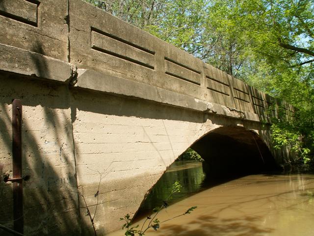
This bridge is a concrete arch bridge of medium size located
on a short dirt road. It's intact original concrete guardrails feature an
outlined rectangle shape inscribed on them. It is a one-lane bridge. It is
listed in the historic bridge inventory as being built in 1910.
The bridge is in good condition, but is in need of some attention to stay in
good condition. Part of the bridge's abutments which also hold up a section of
guardrail appear to be tipping back, pulling a small section of guardrail with
them. The bridge's arch has been patched once, but could be patched again to
address some minor and isolated areas of deterioration.
An inspection of HABS HAER's page showed that a dozen of these types of bridges were built in Macomb County by the Illinois Bridge Company, a prolific company in Michigan at the time. The 1995 Michigan Historic Bridge Inventory showed three other concrete arch bridges built in either 1909 or 1910, suggesting that as late as 1995 there were three other structures remaining in Macomb County that were similar or identical to this one. All of those have been replaced with modern slabs of concrete. Oddly, they were all within a mile of this bridge! The other bridges were 24 Mile Road over N. Branch Clinton River, Fairchild Road over Deer Creek, and 25 Mile Road over Deer Creek. All were built in 1910, except 24 Mile Road, which was built in 1909. Outside of this area is a much larger arch bridge of this design beside the current Romeo Plank bridge over North Branch Clinton River. So, Thus, this bridge has a great deal of local historic significance since it is one of only two remaining examples of a structure type that was once locally common, and is the only one on public roads. With intact guardrails, and no other observed modifications, it is an intact example of a standard plan concrete arch bridge. There is only one other concrete arch bridge of any type in the county, the Gratiot Avenue Bridge, and was not built to the same plan as the Chapman Road and Romeo Plank Road Bridges.
This bridge is tagged with the following special condition(s): Unorganized Photos
![]()
![]()
![]()
![]()
This historic bridge has been demolished. This map is shown for reference purposes only.
Coordinates (Latitude, Longitude):
Search For Additional Bridge Listings:
Bridgehunter.com: View listed bridges within 0.5 miles (0.8 kilometers) of this bridge.
Bridgehunter.com: View listed bridges within 10 miles (16 kilometers) of this bridge.
Additional Maps:
Google Streetview (If Available)
GeoHack (Additional Links and Coordinates)
Apple Maps (Via DuckDuckGo Search)
Apple Maps (Apple devices only)
Android: Open Location In Your Map or GPS App
Flickr Gallery (Find Nearby Photos)
Wikimedia Commons (Find Nearby Photos)
Directions Via Sygic For Android
Directions Via Sygic For iOS and Android Dolphin Browser
USGS National Map (United States Only)
Historical USGS Topo Maps (United States Only)
Historic Aerials (United States Only)
CalTopo Maps (United States Only)

© Copyright 2003-2024, HistoricBridges.org. All Rights Reserved. Disclaimer: HistoricBridges.org is a volunteer group of private citizens. HistoricBridges.org is NOT a government agency, does not represent or work with any governmental agencies, nor is it in any way associated with any government agency or any non-profit organization. While we strive for accuracy in our factual content, HistoricBridges.org offers no guarantee of accuracy. Information is provided "as is" without warranty of any kind, either expressed or implied. Information could include technical inaccuracies or errors of omission. Opinions and commentary are the opinions of the respective HistoricBridges.org member who made them and do not necessarily represent the views of anyone else, including any outside photographers whose images may appear on the page in which the commentary appears. HistoricBridges.org does not bear any responsibility for any consequences resulting from the use of this or any other HistoricBridges.org information. Owners and users of bridges have the responsibility of correctly following all applicable laws, rules, and regulations, regardless of any HistoricBridges.org information.
![]()