

View Information About HSR Ratings
This bridge is part of an interesting historic bridge history Below is a short summary of a series of events of which this bridge is a part. Consider the narrative below.
There are three bridges that are discussed in this article:
North Saginaw Road Bridge - A standard plan parker pony truss.
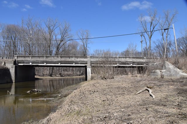
Gratiot Avenue Belle River Bridge - A standard plan concrete and steel beam bridge with decorative concrete railings. You are currently viewing the page for this bridge.
Irish Road Bridge - A concrete camelback bridge.
Back in 1920, Gratiot Road was US-25, a major route connecting Port Huron and Detroit. A bridge was needed to cross the Belle River in St. Clair County, and a pony Parker truss was selected and built there. The bridge was fabricated, and perhaps designed as well, by the Sarnia Bridge Company. In 1927, up in Midland County, this Irish Street Bridge was constructed to carry US-10 over the Salt River. By 1931, Gratiot Road (US-25) was becoming increasingly busy. It was decided that a new beam bridge would be needed there. As a result, the concrete Belle River Bridge was constructed. This is most likely the time when a center lane was added to US-25 to serve as a passing lane for both directions of traffic. The center lane would later be known as a death-lane due to deadly head-on collisions that it caused as a shared passing lane. Gratiot today no longer has that lane, but all the old bridges are wider than the current two-lane road because of this former lane. The wider width of the roadway needed for this passing lane may have been what made the two lane truss bridge, which had only been in service for 12 years, inadequate for the roadway. As a result, a three-lane beam bridge was constructed right beside the parker truss bridge, on the northern side. The truss bridge likely remained open to traffic while this bridge was built. The Parker truss abutments still remain right next to the beam bridge even today, which lead to this assumption. Meanwhile in Midland County, a realignment had been designed for US-10, which relocated the Salt River crossing south a little ways, next to the Pere Marquette Railroad tracks; the site of current day North Saginaw Road. It was decided that the truss bridge from US-25 would work fine for US-10, and it was relocated to the new US-10 crossing in 1932. A standard Michigan State Highway Department Plaque was placed on the abutment for the bridge in Midland County to credit the 1932 repairs and substructure construction. As a result of all this, the Irish Street Bridge, now former US-10 alignment, reverted to local control, having been a trunk line bridge for only five years. The parker truss bridge from St. Clair County likely served US-10 traffic until the US-10 expressway was completed. Upon completion of the US-10 Expressway, North Saginaw Road ceased to be US-10 and was reverted to local control. A side effect of this, would have been reduced traffic on North Saginaw Road, which allowed the truss bridge to still be a viable crossing up to modern times. Recently, Midland County Road Commission decided to replace the Parker truss bridge. The Parker truss bridge was once again relocated and restored, ending up this time on Perrine Road north of the US-10 expressway near Midland. The Parker truss bridge remains open to traffic today in this location.
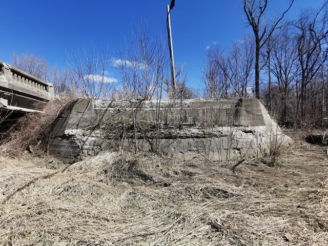
The Gratiot Avenue Belle River Bridge is thus historically significant as a survivor to this story. This is the bridge that replaced the North Saginaw Road Bridge. As mentioned, the abutments on which the Parker truss stood remain next to the existing bridge. These abutments are shown above, and more photos are in the gallery. This bridge, like all the 1930s bridges on this section of Gratiot, is significant as a remnant from a transportation experiment that didn't work, the two-way shared passing lane. All the bridges are clearly wider than they need to be to carry the two lane road that exists today.
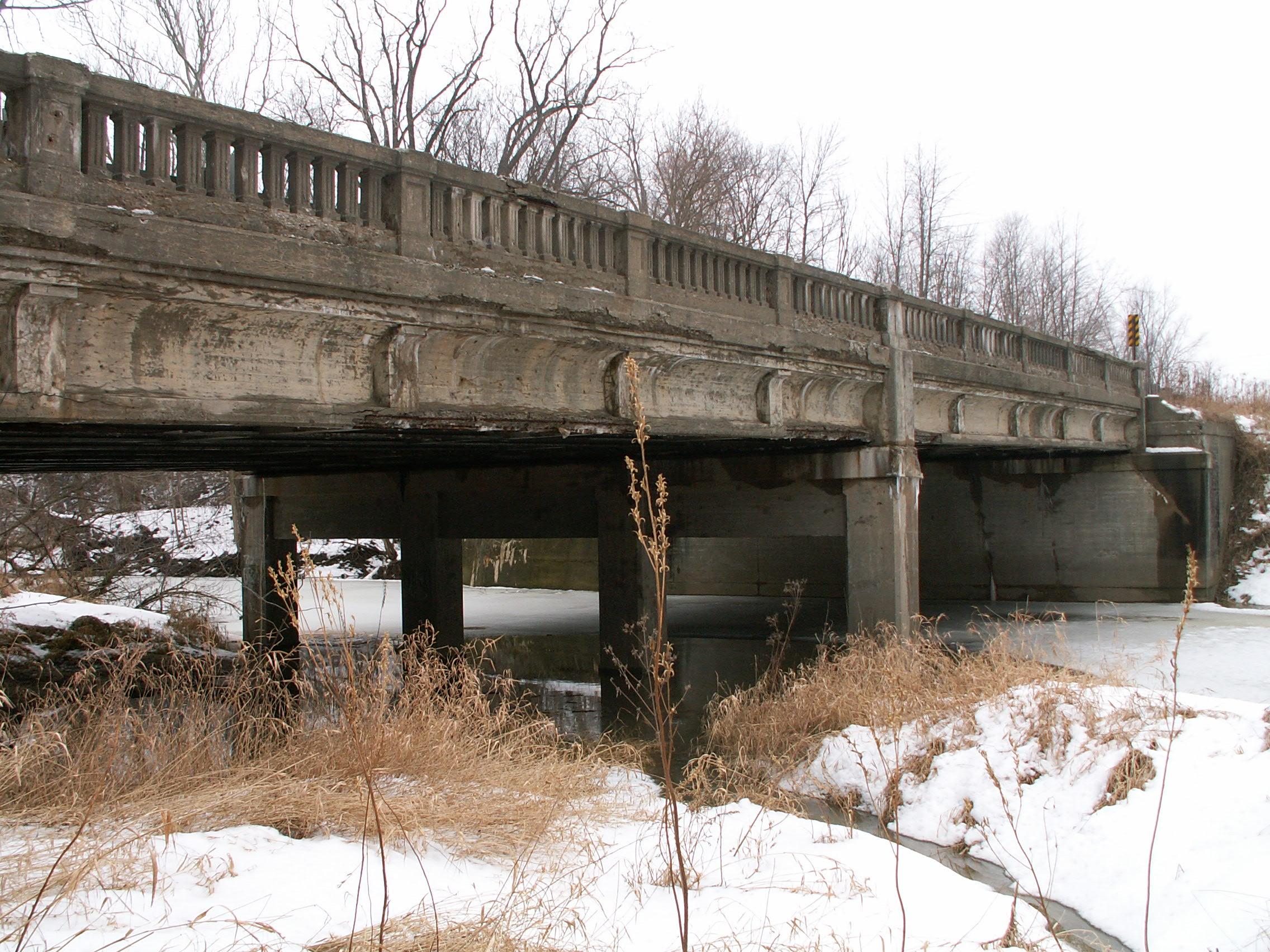
This bridge is a two span structure, which is representative of the trend of building shorter multi-span structures that occurred after the passing of the truss bridge era. Consider that the North Saginaw Road Bridge is a single-span structure.
In terms of condition, the bridge is in good structural shape, with a redone deck. However the original concrete railings have severely spalled, and modern Armco railings have been added on top of that. As a result, the integrity of the historical elements has been severely curtailed.
This bridge is tagged with the following special condition(s): Unorganized Photos
![]()
![]()
![]()
![]()
![]()
![]()
This historic bridge has been demolished. This map is shown for reference purposes only.
Coordinates (Latitude, Longitude):
Search For Additional Bridge Listings:
Bridgehunter.com: View listed bridges within 0.5 miles (0.8 kilometers) of this bridge.
Bridgehunter.com: View listed bridges within 10 miles (16 kilometers) of this bridge.
Additional Maps:
Google Streetview (If Available)
GeoHack (Additional Links and Coordinates)
Apple Maps (Via DuckDuckGo Search)
Apple Maps (Apple devices only)
Android: Open Location In Your Map or GPS App
Flickr Gallery (Find Nearby Photos)
Wikimedia Commons (Find Nearby Photos)
Directions Via Sygic For Android
Directions Via Sygic For iOS and Android Dolphin Browser
USGS National Map (United States Only)
Historical USGS Topo Maps (United States Only)
Historic Aerials (United States Only)
CalTopo Maps (United States Only)

© Copyright 2003-2024, HistoricBridges.org. All Rights Reserved. Disclaimer: HistoricBridges.org is a volunteer group of private citizens. HistoricBridges.org is NOT a government agency, does not represent or work with any governmental agencies, nor is it in any way associated with any government agency or any non-profit organization. While we strive for accuracy in our factual content, HistoricBridges.org offers no guarantee of accuracy. Information is provided "as is" without warranty of any kind, either expressed or implied. Information could include technical inaccuracies or errors of omission. Opinions and commentary are the opinions of the respective HistoricBridges.org member who made them and do not necessarily represent the views of anyone else, including any outside photographers whose images may appear on the page in which the commentary appears. HistoricBridges.org does not bear any responsibility for any consequences resulting from the use of this or any other HistoricBridges.org information. Owners and users of bridges have the responsibility of correctly following all applicable laws, rules, and regulations, regardless of any HistoricBridges.org information.
![]()