

View Information About HSR Ratings
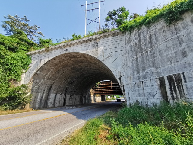
This fairly early concrete arch bridge is an impressive gateway into Cairo and is next to a historic riveted floodgate that was built in 1914 next to the bridge. This bridge is locally known as a tunnel due to its considerable arch width, 94 feet.
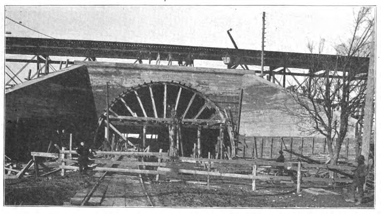
The construction of this arch bridge was complicated by the deep deck trusses of the previous bridge. The arch had to literally be built around the trusses of the previous truss bridge, which were carefully removed after the arch bridge was completed. Prior to removal of the truss, the truss members passed right through the concrete arch. See the linked historical article for more information.
The riveted steel plate floodgate is a counterweighted structure that remains in place today and was originally designed to be lowered into place during floods. The flood gate was built by Stupp Brothers Bridge and Iron Company of St. Louis, Missouri. The floodgate is no longer used. It would appear that modular flood control gates stored off-site would be hauled in and inserted into a slot into the abutment of another nearby bridge in the event of a major flood today. Photos of the floodgate are included in the photo gallery.
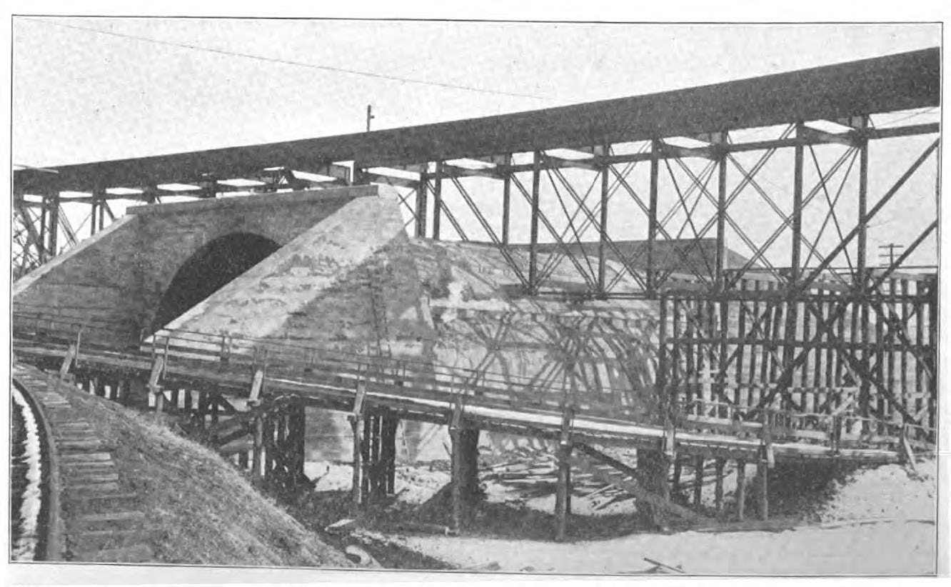
Above: Historical photo showing bridge construction. This photo shows the arch centering (falsework).
Above: Historical photo showing bridge construction. This photo shows how the arch had to literally be built around the trusses of the previous truss bridge, which were carefully removed after the arch bridge was completed.

Above: View of floodgate.
![]()
![]()
![]()
Coordinates (Latitude, Longitude):
Search For Additional Bridge Listings:
Bridgehunter.com: View listed bridges within 0.5 miles (0.8 kilometers) of this bridge.
Bridgehunter.com: View listed bridges within 10 miles (16 kilometers) of this bridge.
Additional Maps:
Google Streetview (If Available)
GeoHack (Additional Links and Coordinates)
Apple Maps (Via DuckDuckGo Search)
Apple Maps (Apple devices only)
Android: Open Location In Your Map or GPS App
Flickr Gallery (Find Nearby Photos)
Wikimedia Commons (Find Nearby Photos)
Directions Via Sygic For Android
Directions Via Sygic For iOS and Android Dolphin Browser
USGS National Map (United States Only)
Historical USGS Topo Maps (United States Only)
Historic Aerials (United States Only)
CalTopo Maps (United States Only)

© Copyright 2003-2024, HistoricBridges.org. All Rights Reserved. Disclaimer: HistoricBridges.org is a volunteer group of private citizens. HistoricBridges.org is NOT a government agency, does not represent or work with any governmental agencies, nor is it in any way associated with any government agency or any non-profit organization. While we strive for accuracy in our factual content, HistoricBridges.org offers no guarantee of accuracy. Information is provided "as is" without warranty of any kind, either expressed or implied. Information could include technical inaccuracies or errors of omission. Opinions and commentary are the opinions of the respective HistoricBridges.org member who made them and do not necessarily represent the views of anyone else, including any outside photographers whose images may appear on the page in which the commentary appears. HistoricBridges.org does not bear any responsibility for any consequences resulting from the use of this or any other HistoricBridges.org information. Owners and users of bridges have the responsibility of correctly following all applicable laws, rules, and regulations, regardless of any HistoricBridges.org information.
![]()