

View Information About HSR Ratings
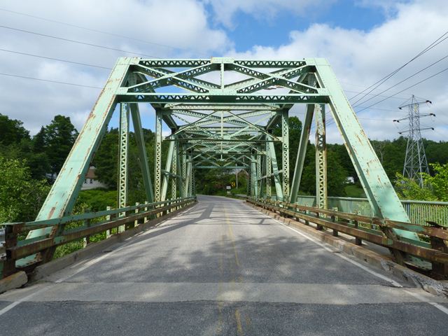
This bridge is located immediately west of the larger, continuous Bar Mills Bridge. The bridge is a state standard through truss bridge. While the nearby Bar Mills Bridge is a very rare and unusual continuous truss, it shares the stylistic details such as truss configuration, portal bracing design, and choice of built-up beam style with this shorter, single simple span bridge. The canal bridge carries the road over a short canal that parallels the Saco River. Since this bridge is of the same dimensions and condition as the Bar Mills Bridge, and carries the same road, it shares the same risk of demolition as its larger brother.
Information and Findings From Maine's Historic Bridge InventoryDiscussion of Bridge "The 1937 riveted, Warren thru truss bridge was built as part of the same project as #3333, which is historically significant as an early application of the continuous design to truss bridges in Maine. The first examples of continuous truss bridges in Maine were for replacements of bridges lost in the March, 1936 flood. This one span bridge is not technologically significant in its own right but is in association with the Bar Mills bridge. The bridge is judged to have average preservation priority because an example of a bridge type that is considered common in the state." Bridge Considered Historic By Survey: Yes |
![]()
![]()
![]()
This historic bridge has been demolished. This map is shown for reference purposes only.
Demolished 2017.
Coordinates (Latitude, Longitude):
Search For Additional Bridge Listings:
Bridgehunter.com: View listed bridges within 0.5 miles (0.8 kilometers) of this bridge.
Bridgehunter.com: View listed bridges within 10 miles (16 kilometers) of this bridge.
Additional Maps:
Google Streetview (If Available)
GeoHack (Additional Links and Coordinates)
Apple Maps (Via DuckDuckGo Search)
Apple Maps (Apple devices only)
Android: Open Location In Your Map or GPS App
Flickr Gallery (Find Nearby Photos)
Wikimedia Commons (Find Nearby Photos)
Directions Via Sygic For Android
Directions Via Sygic For iOS and Android Dolphin Browser
USGS National Map (United States Only)
Historical USGS Topo Maps (United States Only)
Historic Aerials (United States Only)
CalTopo Maps (United States Only)

© Copyright 2003-2024, HistoricBridges.org. All Rights Reserved. Disclaimer: HistoricBridges.org is a volunteer group of private citizens. HistoricBridges.org is NOT a government agency, does not represent or work with any governmental agencies, nor is it in any way associated with any government agency or any non-profit organization. While we strive for accuracy in our factual content, HistoricBridges.org offers no guarantee of accuracy. Information is provided "as is" without warranty of any kind, either expressed or implied. Information could include technical inaccuracies or errors of omission. Opinions and commentary are the opinions of the respective HistoricBridges.org member who made them and do not necessarily represent the views of anyone else, including any outside photographers whose images may appear on the page in which the commentary appears. HistoricBridges.org does not bear any responsibility for any consequences resulting from the use of this or any other HistoricBridges.org information. Owners and users of bridges have the responsibility of correctly following all applicable laws, rules, and regulations, regardless of any HistoricBridges.org information.
![]()