

View Information About HSR Ratings
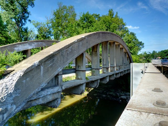
This is an exceedingly rare surviving example of a concrete rainbow arch bridge in Ohio. The bridge was bypassed by replacement bridge but was wisely left standing for its historic value. Although the bridge is has serious deterioration, the bridge could and should be restored for non-motorized use. Rainbow arch bridges are among the most beautiful types of concrete bridge and they greatly enhance the beauty of any location where they exist. They are rare, not only in Ohio but throughout North America. Even in the places where they are most populous (State of Kansas and Province of Ontario) they are still very uncommon.
Information and Findings From Ohio's Historic Bridge InventorySetting/Context The bridge carries a pedestrian walkway over a stream in suburban setting of early to mid-20th-century residences. The bridge is closed to traffic and bypassed by a modern steel stringer bridge that carries Oberlin-Elyria Road over the same feature. Historically the bypassed road segment was SR 20. Physical Description The 1 span, 125'-long, reinforced-concrete thru (rainbow) arch bridge has paneled arch ribs, vertical hangers, and articulated floorbeams with slab deck. The U-shaped wingwalls are finished with paneled concrete parapets. Original railings have been replaced with beam guide rails on the span itself. Integrity Loss of original fabric from spalling/deterioration. It is in sore need of some attention. Summary of Significance The 1923 reinforced-concrete rainbow arch bridge is
a technologically significant example of an increasingly rare
type/design. It has loss of original fabric, but retains sufficient
integrity of design/materials to convey its significance. The inventory
has identified seven surviving examples dating from 1909 to 1930 (Phase
1A Update, 2008). This one, like several others, appears to be the state
bridge bureau's design that was in use during the 1920s to early 1930s
based on the details. Justification The bridge is one of 5 remaining examples of the type that was once not uncommon in Ohio. It offered an aesthetic treatment preferred in urban and picturesque settings. The 6 examples date from 1909 to 1930, and each is of high significance given their limited numbers and importance within the context as the aesthetic alternative to the thru truss bridge. Additional Comments One-span, 125'-long, reinforced concrete, tied "rainbow" arch bridge with articulated floorbeams. Concrete paneled parapets at east approaches. 24'-wide deck. Modern guide rail attached to inside of floorbeam hangers. Asphalt wearing surface. Deterioration causing loss of original fabric. Extensive deterioration, especially at bridge ends and ends of floorbeams. Super is critical condition, sub is serious condition. In need of routine maintenance. Bridge Management Plan Comments The bridge has already been bypassed and has been
closed to vehicular traffic for many years. Even though it carries an
active SFN and is included in the NBI database, there is limited
information as to its current condition and functionality. The approach
roadway width is for the new road; there are no approaches to this
bypassed bridge, which sits in isolation north (upstream) of the new
road and between two houses. The bridge is deficient in condition, and
it apparently is not maintained by the county, which is listed as its
owner. The superstructure, with its deteriorating reinforced concrete
and exposed reinforcing steel, is in critical (2) condition, the
substructure is serious (3), and the general condition appraisal is
critical (2). The reinforced concrete parapet at one approach has
failed. Because this is a pedestrian bridge, geometric adequacy is not
an issue. The bridge is already bypassed. Access to the bridge is limited, and there is no off-road parking that encourages visitation. The old approach exists on the west side, and there are modern houses beyond the north side of each end of the bridge, and the new road on a new alignment are immediately to the south. There appears to be no opportunity for constructing a path or trail to encourage enjoyment of the bridge. A private golf course is to the south of the new highway, but there is no physical way to link this bridge to the club grounds. Pending the results from the concrete testing and load analysis, it is feasible and prudent to address the deterioration of the reinforced concrete. Conventional methods are available to make and finish the repairs without adversely affecting it. These techniques include pneumatically applied concrete. Load-carrying capacity is not a significant factor as the bridge serves for limited pedestrian use only. It has no potential to be anything but an isolated and infrequently visited bypassed bridge. Preservation Recomendations -- County forces should immediately and seasonally thereafter clean debris and growth from the bearings area, the deck, and the area around the abutments. This will lessen the advancing deterioration and make the historic bridge more appealing to inspection by passersby. -- As soon as possible, maintenance forces should install hot-poured rubber joint sealant at cracks along the curb lines where water intrusion is occurring. -- Develop and install features that encourage visitation. This could include interpretive panels that describe the historic bridge, off-road parking, and a picnic table and trash can. The bridge is not that far from the county engineers office, so maintenance of a "pocket park" should not be onerous to the county. -- Make needed repairs to stop active deterioration of concrete and reinforcing steel. This could include using a shotcrete method once deteriorated material has been removed and proper surface preparation has been done, including replacing reinforcing as needed. Bridge is abandoned and not maintained. Consequently it is overgrown at the abutments and debris has accumulated on the deck; both are trapping moisture that affects deterioration. Approaches should be cleaned by county forces to prevent debris and growth from accelerating deterioration. An entity needs to step forward and advocate for preservation of the rare bridge type (only 5 complete examples remain in state). It should be determined if there is an easement or agreement of responsibility to maintain/preserve the bypassed bridge. If there is, it should be enforced. If there is not, an agreement should be established, and county engineer or their designee should solicit a group to be responsible for the bridge on its behalf. A means to fund the needed in kind repairs to bridge and cyclical maintenance should be identified or developed. Bridge Considered Historic By Survey: Yes, High Significance |
![]()
![]()
![]()
Coordinates (Latitude, Longitude):
Search For Additional Bridge Listings:
Bridgehunter.com: View listed bridges within 0.5 miles (0.8 kilometers) of this bridge.
Bridgehunter.com: View listed bridges within 10 miles (16 kilometers) of this bridge.
Additional Maps:
Google Streetview (If Available)
GeoHack (Additional Links and Coordinates)
Apple Maps (Via DuckDuckGo Search)
Apple Maps (Apple devices only)
Android: Open Location In Your Map or GPS App
Flickr Gallery (Find Nearby Photos)
Wikimedia Commons (Find Nearby Photos)
Directions Via Sygic For Android
Directions Via Sygic For iOS and Android Dolphin Browser
USGS National Map (United States Only)
Historical USGS Topo Maps (United States Only)
Historic Aerials (United States Only)
CalTopo Maps (United States Only)

© Copyright 2003-2024, HistoricBridges.org. All Rights Reserved. Disclaimer: HistoricBridges.org is a volunteer group of private citizens. HistoricBridges.org is NOT a government agency, does not represent or work with any governmental agencies, nor is it in any way associated with any government agency or any non-profit organization. While we strive for accuracy in our factual content, HistoricBridges.org offers no guarantee of accuracy. Information is provided "as is" without warranty of any kind, either expressed or implied. Information could include technical inaccuracies or errors of omission. Opinions and commentary are the opinions of the respective HistoricBridges.org member who made them and do not necessarily represent the views of anyone else, including any outside photographers whose images may appear on the page in which the commentary appears. HistoricBridges.org does not bear any responsibility for any consequences resulting from the use of this or any other HistoricBridges.org information. Owners and users of bridges have the responsibility of correctly following all applicable laws, rules, and regulations, regardless of any HistoricBridges.org information.
![]()