

View Information About HSR Ratings


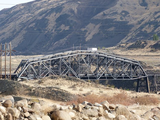
This is a very unusual bridge with an unusual and interesting history. In addition to its deck girder approach spans, this bridge includes a main through truss span and an unusual Parker deck truss approach span located immediately north of the through truss span. During construction in 1893, each half of the deck truss span was erected on either side of the piers of the main span truss, and were used as counterweights (anchor spans) to balance the through truss span out during construction, so each half of the through truss span could be erected via the cantilever method avoiding the use of falsework in the Columbia River. This is interesting in its own right, but even more interesting is that while the deck truss spans were being used as anchors, they were erected with the trusses above the roadway like a through truss; essentially they were erected upside down for this part of construction. The use of parts from another span to anchor the construction of another span on this bridge may have inspired future projects such as that of the Ohio Connecting Bridge in Pittsburgh.

The unusual story of the bridge does not end here. In 1925, supplemental trusses were added to both the through and deck truss spans. The shape of the added trusses are not identical to the original trusses and as a result, the trusses combine together visually to form a very unusual looking bridge.
Thanks to a historical photo of the 1925 project provided to HistoricBridges.org by Jenny Lynn, the construction process for the 1925 project has been revealed. Similar to that of the 1893-4 trusses, the construction of the supplemental trusses was conducted by anchoring the supplemental truss during erection. This time however, the anchoring process was done a bit differently. At the south end of the bridge, a pin-connected truss structure was used as an anchor. This structure was most likely about 3/4 of the truss parts that ultimately became the supplemental truss for the deck truss approach span. This 3/4 of a truss was set up on an incline, with the far end of the anchor resting on the ground, and the other end at the height of the pier cap. At the north end of the bridge, a rivet-connected truss structure was positioned in a similar manner. The rivet-connected anchor truss was not reused as part of the final bridge product, and was only in use as a temporary structure for this project. It is not known if this rivet-connected truss structure was a salvaged truss span from some bridge, or whether it was purposely built to be used as a temporary anchor structure.

Above: Historical photo showing the 1925 strengthening project during construction with the temporary anchor spans in place. Click for enlargement. Photo provided courtesy Jenny Lynn.
![]()
![]()
![]()
Coordinates (Latitude, Longitude):
Search For Additional Bridge Listings:
Bridgehunter.com: View listed bridges within 0.5 miles (0.8 kilometers) of this bridge.
Bridgehunter.com: View listed bridges within 10 miles (16 kilometers) of this bridge.
Additional Maps:
Google Streetview (If Available)
GeoHack (Additional Links and Coordinates)
Apple Maps (Via DuckDuckGo Search)
Apple Maps (Apple devices only)
Android: Open Location In Your Map or GPS App
Flickr Gallery (Find Nearby Photos)
Wikimedia Commons (Find Nearby Photos)
Directions Via Sygic For Android
Directions Via Sygic For iOS and Android Dolphin Browser
USGS National Map (United States Only)
Historical USGS Topo Maps (United States Only)
Historic Aerials (United States Only)
CalTopo Maps (United States Only)

© Copyright 2003-2024, HistoricBridges.org. All Rights Reserved. Disclaimer: HistoricBridges.org is a volunteer group of private citizens. HistoricBridges.org is NOT a government agency, does not represent or work with any governmental agencies, nor is it in any way associated with any government agency or any non-profit organization. While we strive for accuracy in our factual content, HistoricBridges.org offers no guarantee of accuracy. Information is provided "as is" without warranty of any kind, either expressed or implied. Information could include technical inaccuracies or errors of omission. Opinions and commentary are the opinions of the respective HistoricBridges.org member who made them and do not necessarily represent the views of anyone else, including any outside photographers whose images may appear on the page in which the commentary appears. HistoricBridges.org does not bear any responsibility for any consequences resulting from the use of this or any other HistoricBridges.org information. Owners and users of bridges have the responsibility of correctly following all applicable laws, rules, and regulations, regardless of any HistoricBridges.org information.
![]()