

View Information About HSR Ratings
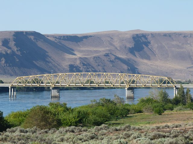
This bridge is unusual because its three main spans have polygonal top chords that are oriented in a manner that the three spans form a single arch shape, making the bridge look like a single continuous three-span truss. However, in reality the trusses are three simple spans. Mark Bozanich commented on www.bridgehunter.com that the Vernita Bridge was built with three simple trusses so that the center truss could be converted to a vertical lift span. There were plans at one time to build a dam downstream from Vernita and upstream from the Tri-Cities equipped with locks. Plans were abandoned now that the dam site is part of the Hanford Reach National Monument. Mark's comments seem to be supported by the physical configuration of the truss. Most notably, the piers for the center truss span are quite a bit wider than they need to be, suggesting that the piers were built to either completely or partially accommodate the towers that would be needed to make the bridge a vertical lift. Also, at the pier, the vertical end posts have empty bolt holes which could have been intended for attaching the lift tower and related materials.
The bridge is a late example of a metal truss bridge, and barely old enough to be considered historic. However, the bridge does stand out for its unusual false-continuous design. It also represents the end of the riveted truss era. Truss bridges built in the 60s like this bridge usually have details that show the decline in use of rivets and increase in the use of welds and bolts. What is unusual is that this bridge still used riveted connections, instead of bolted connections which are often found on 1960s bridges. In contrast, the built-up beams that compose the truss are welded, which is unusual since the built-up beams is one location where rivets are often still found on 1960s bridges.
![]()
![]()
![]()
Coordinates (Latitude, Longitude):
Search For Additional Bridge Listings:
Bridgehunter.com: View listed bridges within 0.5 miles (0.8 kilometers) of this bridge.
Bridgehunter.com: View listed bridges within 10 miles (16 kilometers) of this bridge.
Additional Maps:
Google Streetview (If Available)
GeoHack (Additional Links and Coordinates)
Apple Maps (Via DuckDuckGo Search)
Apple Maps (Apple devices only)
Android: Open Location In Your Map or GPS App
Flickr Gallery (Find Nearby Photos)
Wikimedia Commons (Find Nearby Photos)
Directions Via Sygic For Android
Directions Via Sygic For iOS and Android Dolphin Browser
USGS National Map (United States Only)
Historical USGS Topo Maps (United States Only)
Historic Aerials (United States Only)
CalTopo Maps (United States Only)

© Copyright 2003-2024, HistoricBridges.org. All Rights Reserved. Disclaimer: HistoricBridges.org is a volunteer group of private citizens. HistoricBridges.org is NOT a government agency, does not represent or work with any governmental agencies, nor is it in any way associated with any government agency or any non-profit organization. While we strive for accuracy in our factual content, HistoricBridges.org offers no guarantee of accuracy. Information is provided "as is" without warranty of any kind, either expressed or implied. Information could include technical inaccuracies or errors of omission. Opinions and commentary are the opinions of the respective HistoricBridges.org member who made them and do not necessarily represent the views of anyone else, including any outside photographers whose images may appear on the page in which the commentary appears. HistoricBridges.org does not bear any responsibility for any consequences resulting from the use of this or any other HistoricBridges.org information. Owners and users of bridges have the responsibility of correctly following all applicable laws, rules, and regulations, regardless of any HistoricBridges.org information.
![]()